Cyclocane
( cyclocane is a CYCLOne and hurriCANE tracker by hayley )
English Español Deutsch Français 日本語
This is the final warning / advisory for this storm as it has weakened below warning levels and/or the storm system is no longer a tropical cyclone.
ORLENE Current Status
...ORLENE DISSIPATES, BUT THE HEAVY RAINFALL THREAT CONTINUES OVERNIGHT...
Current Wind Speed 20 knots / 25 MPH
Max Predicted Wind Speed 20 knots / 25 MPH at

ORLENE Land Hazards
- RAINFALL - Orlene is expected to produce an additional inch or two of rain across portions of western Mexico into Tuesday, bringing storm total amounts to 10 inches locally. This rainfall could lead to flash flooding, as well as possible landslides in areas of rugged terrain.
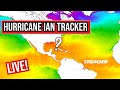
ORLENE Tracker
ORLENE Satellite Loop

ORLENE Alternate Tracking Map
ORLENE Spaghetti Models
Spaghetti models for ORLENE can be found here:
ORLENE spaghetti models page »
ORLENE Watches and Warnings

Remnants Of ORLENE Tropical Cyclone Update
Remnants Of ORLENE Public Advisory
000
WTPZ31 KNHC 040233
TCPEP1

BULLETIN
Remnants Of Orlene Advisory Number  22
NWS National Hurricane Center Miami FL       EP162022
1000 PM CDT Mon Oct 03 2022

...ORLENE DISSIPATES, BUT THE HEAVY RAINFALL THREAT CONTINUES
OVERNIGHT...


SUMMARY OF 1000 PM CDT...0300 UTC...INFORMATION
-----------------------------------------------
LOCATION...24.0N 105.0W
ABOUT 105 MI...170 KM ENE OF MAZATLAN MEXICO
MAXIMUM SUSTAINED WINDS...25 MPH...35 KM/H
PRESENT MOVEMENT...NE OR 40 DEGREES AT 6 MPH...9 KM/H
MINIMUM CENTRAL PRESSURE...1008 MB...29.77 INCHES


WATCHES AND WARNINGS
--------------------
None.


DISCUSSION AND OUTLOOK
----------------------
At 1000 PM CDT (0300 UTC), the remnants of Orlene were located near
latitude 24.0 North, longitude 105.0 West. The remnants are moving
toward the northeast near 6 mph (9 km/h).

Maximum sustained winds are near 25 mph (35 km/h) with higher gusts.
The remnants are expected to totally dissipate overnight.

The estimated minimum central pressure is 1008 mb (29.77 inches).


HAZARDS AFFECTING LAND
----------------------
RAINFALL: Orlene is expected to produce an additional inch or two of
rain across portions of western Mexico into Tuesday, bringing storm
total amounts to 10 inches locally.  This rainfall could lead to
flash flooding, as well as possible landslides in areas of rugged
terrain.


NEXT ADVISORY
-------------
This is the last public advisory issued by the National Hurricane
Center on this system.

$$
Forecaster Blake
Public Advisory not available for this storm.
Remnants Of ORLENE Forecast Discussion
000
WTPZ41 KNHC 040234
TCDEP1

Remnants Of Orlene Discussion Number  22
NWS National Hurricane Center Miami FL       EP162022
1000 PM CDT Mon Oct 03 2022

Visible satellite imagery indicates that Orlene has dissipated over
the Sierra Madre mountains of Mexico, with no trace of a low-level
circulation.  Thus, this is the last advisory.  Moisture from
Orlene could still lead to flash flooding and landslides through
Tuesday in southwestern Mexico.

Key Messages:

1. Lingering rainfall from Orlene could lead to flash flooding, as
well as possible landslides in areas of rugged terrain of
southwestern Mexico into Tuesday.


FORECAST POSITIONS AND MAX WINDS

INIT  04/0300Z 24.0N 105.0W   20 KT  25 MPH...REMNANTS OF
 12H  04/1200Z...DISSIPATED

$$
Forecaster Blake
ORLENE storm path from NHC
| Time | Speed | Location | Status |
|---|---|---|---|
| 20 knots | 24.0, -105.0 | REMNANTS OF | |
| 0 knots | translation missing: en.DISSIPATED |
site by Hayley Croft
Want to help support this site?
- Tell your friends about Cyclocane
- make a donation - totally optional but completely appreciated
Make a monthly donation or a one-time donation to help support ongoing costs with Cyclocane.
Play solitaire and track all of the cyclocane storms at the same time at Hurricane Solitaire.