Cyclocane
( cyclocane is a CYCLOne and hurriCANE tracker by hayley )


English Español Deutsch Français 日本語
This is the final warning / advisory for this storm as it has weakened below warning levels and/or the storm system is no longer a tropical cyclone.
HAROLD Current Status
Current Wind Speed 20 knots / 25 MPH
Max Predicted Wind Speed 20 knots / 25 MPH at

Current Watches/Warnings / Radar / Satellite
current US watches/warnings

live tornado/thunderstorm tracker - tornadohq
future radar imagery - my future radar

future radar imagery

(above image is an example of the Western North Atlantic page - see Atlantic future radar page for a full set of images)
If a tropical storm or hurricane is threatening land, you can check my future radar for an idea of what radar might look like as the storm approaches.
HAROLD Land Hazards
NWS Local Hurricane Statements
- No warnings
- RAINFALL - Harold is expected to produce rainfall amounts of 2 to 4 inches, with isolated higher amounts of 6 inches, across South Texas through early Wednesday. Scattered instances of flash flooding will be possible.
- WIND - Gusty winds are possible in portions of southern Texas and northern Mexico through tonight.
- STORM SURGE - Water levels will continue to recede through this evening. For information specific to your area, please see products issued by your local National Weather Service forecast office.
- SURF - Swells are expected to diminish near the coast of south Texas through this evening. Please consult products from your local weather office.
HAROLD Tracker
HAROLD Satellite Loop
HAROLD Alternate Tracking Map
HAROLD Spaghetti Models
Spaghetti models for HAROLD can be found here:
HAROLD spaghetti models page »
HAROLD Watches and Warnings
Remnants Of HAROLD Tropical Cyclone Update
Remnants Of HAROLD Public Advisory
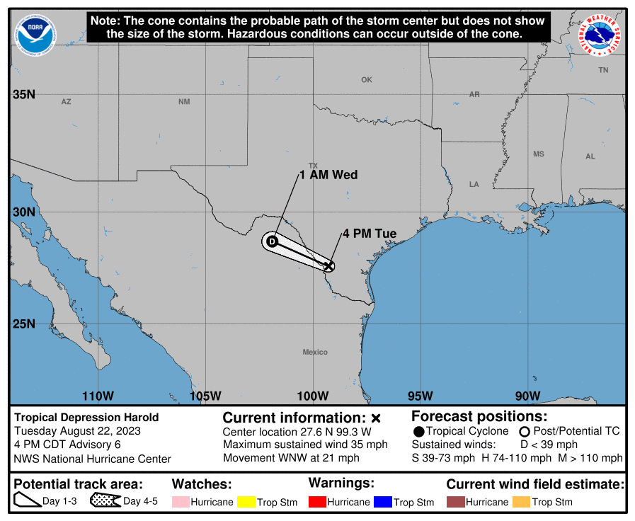
000
WTNT34 KNHC 222038
TCPAT4

BULLETIN
Tropical Depression Harold Advisory Number   6
NWS National Hurricane Center Miami FL       AL092023
400 PM CDT Tue Aug 22 2023

...HAROLD WEAKENS TO A DEPRESSION BUT HEAVY RAINS CONTINUE...
...NEXT ADVISORY WILL BE ISSUED BY THE WEATHER PREDICTION CENTER...


SUMMARY OF 400 PM CDT...2100 UTC...INFORMATION
----------------------------------------------
LOCATION...27.6N 99.3W
ABOUT 15 MI...25 KM E OF LAREDO TEXAS
MAXIMUM SUSTAINED WINDS...35 MPH...55 KM/H
PRESENT MOVEMENT...WNW OR 290 DEGREES AT 21 MPH...33 KM/H
MINIMUM CENTRAL PRESSURE...999 MB...29.50 INCHES


WATCHES AND WARNINGS
--------------------
CHANGES WITH THIS ADVISORY:

All Tropical Storm Warnings have been discontinued.

SUMMARY OF WATCHES AND WARNINGS IN EFFECT:

There are no coastal watches or warnings in effect.

Interests in southern Texas and northern Mexico should continue to
monitor the progress of this system.


DISCUSSION AND OUTLOOK
----------------------
At 400 PM CDT (2100 UTC), the center of Tropical Depression Harold
was located inland near latitude 27.6 North, longitude 99.3 West.
The depression is moving toward the west-northwest near 21 mph (33
km/h), and this motion should continue until it dissipates on
Wednesday.

Maximum sustained winds have decreased to near 35 mph (55 km/h)
with higher gusts.  Continued weakening is expected.

The estimated minimum central pressure is 999 mb (29.50 inches).


HAZARDS AFFECTING LAND
----------------------
Key messages for Harold can be found in the Tropical Cyclone
Discussion under AWIPS header MIATCDAT4 and WMO header WTNT44 KNHC
and on the web at hurricanes.gov/text/MIATCDAT4.shtml.

RAINFALL: Harold is expected to produce rainfall amounts of 2 to 4
inches, with isolated higher amounts of 6 inches, across South Texas
through early Wednesday.  Scattered instances of flash flooding will
be possible.

Across Mexico, rainfall amounts of 4 to 6 inches, with local amounts
of 10 inches, are expected across portions of northern Coahuila and
northern Nuevo Leon through Wednesday.  Scattered instances of flash
flooding are expected.

WIND: Gusty winds are possible in portions of southern Texas and
northern Mexico through tonight.

STORM SURGE:  Water levels will continue to recede through this
evening. For information specific to your area, please see products
issued by your local National Weather Service forecast office.

SURF: Swells are expected to diminish near the coast of south Texas
through this evening. Please consult products from your local
weather office.


NEXT ADVISORY
-------------
This is the last public advisory issued by the National Hurricane
Center on Harold. Future information on this system can be found in
Public Advisories issued by the Weather Prediction
Center beginning at 1000 PM CDT, under AWIPS header TCPAT4, WMO
header WTNT24 KWNH, and on the web at www.hurricanes.gov.

$$
Forecaster Cangialosi
Public Advisory not available for this storm.
Remnants Of HAROLD Forecast Discussion
ZCZC NFDTCDAT4 ALL
TTAA00 KWNH DDHHMM

Remnants Of Harold Discussion Number   9
NWS Weather Prediction Center College Park MD   AL092023
1000 AM CDT Wed Aug 23 2023

KEY MESSAGES:

1. Heavy rainfall from Harold shifting through the Trans Pecos
region west of the Texas Big Bend and into southern New Mexico will
produce isolated to widely scattered flash flooding through tonight.
Across northern portions of the Mexican state of Chihuahua, isolated
instances of flash flooding are expected with landslides possible in
mountainous terrain.


FORECAST POSITIONS AND MAX WINDS

INIT  23/1500Z 30.4N 104.4W   20 KT  25 MPH
 12H  24/0000Z...DISSIPATED


$$
Carbin

NNNN
HAROLD storm path from NHC
| Time | Speed | Location | Status |
|---|---|---|---|
| 20 knots | 30.4, -104.4 | ||
| 0 knots | translation missing: en.DISSIPATED |
site by Hayley Croft
- Tell your friends about Cyclocane
- make a donation - totally optional but completely appreciated
Make a monthly donation or a one-time donation to help support ongoing costs with Cyclocane.
Play solitaire and track all of the cyclocane storms at the same time at Hurricane Solitaire.