Cyclocane
( cyclocane is a CYCLOne and hurriCANE tracker by hayley )
English Español Deutsch Français 日本語
This is the final warning / advisory for this storm as it has weakened below warning levels and/or the storm system is no longer a tropical cyclone.
DANIELLE Current Status
Current Wind Speed 55 knots / 65 MPH
Max Predicted Wind Speed 55 knots / 65 MPH at
Current Watches/Warnings / Radar / Satellite
current US watches/warnings

live tornado/thunderstorm tracker - tornadohq
future radar imagery - my future radar

future radar imagery

(above image is an example of the Western North Atlantic page - see Atlantic future radar page for a full set of images)
If a tropical storm or hurricane is threatening land, you can check my future radar for an idea of what radar might look like as the storm approaches.
DANIELLE Land Hazards
NWS Local Hurricane Statements
- No warnings
DANIELLE Tracker
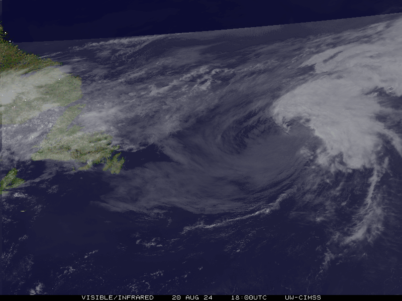
DANIELLE Satellite Loop
DANIELLE Alternate Tracking Map
DANIELLE Spaghetti Models
Spaghetti models for DANIELLE can be found here:
DANIELLE spaghetti models page »
DANIELLE Watches and Warnings

Post-Tropical Cyclone DANIELLE Tropical Cyclone Update
Post-Tropical Cyclone DANIELLE Public Advisory
000
WTNT35 KNHC 081438
TCPAT5

BULLETIN
Post-Tropical Cyclone Danielle Advisory Number  30
NWS National Hurricane Center Miami FL       AL052022
300 PM GMT Thu Sep 08 2022

...DANIELLE NOW POST-TROPICAL...
...THIS IS THE LAST NHC ADVISORY...


SUMMARY OF 300 PM GMT...1500 UTC...INFORMATION
----------------------------------------------
LOCATION...47.9N 31.0W
ABOUT 715 MI...1145 KM NNW OF THE AZORES
MAXIMUM SUSTAINED WINDS...65 MPH...100 KM/H
PRESENT MOVEMENT...NNE OR 20 DEGREES AT 14 MPH...22 KM/H
MINIMUM CENTRAL PRESSURE...973 MB...28.74 INCHES


WATCHES AND WARNINGS
--------------------
There are no coastal watches or warnings in effect.


DISCUSSION AND OUTLOOK
----------------------
At 300 PM GMT (1500 UTC), the center of Post-Tropical Cyclone
Danielle was located near latitude 47.9 North, longitude 31.0 West.
The post-tropical cyclone is moving toward the north-northeast near
14 mph (22 km/h). The post-tropical cyclone is forecast to make a
gradual counter-clockwise loop during the next 36 h, and then move
generally southeastward to east-southeastward through the weekend.

Maximum sustained winds have decreased to near 65 mph (100 km/h)
with higher gusts. Danielle is forecast to remain a large
post-tropical cyclone over the north Atlantic for the next several
days, even as its peak winds slowly decrease.

Tropical-storm-force winds extend outward up to 230 miles (370 km)
from the center.

The estimated minimum central pressure is 973 mb (28.74 inches).


HAZARDS AFFECTING LAND
----------------------
None.


NEXT ADVISORY
-------------
This is the last public advisory issued by the National Hurricane
Center on this system. Additional information on this system can be
found in High Seas Forecasts issued by Meteo France under WMO
header FQNT50 LFPW and available on the web at
www.meteofrance.com/previsions-meteo-marine/bulletin/grandlarge/
metarea2. Additional information may also be found found in High
Seas Forecasts issued by the UK Met Office under WMO header FQNT21
EGRR and on the web at
metoffice.gov.uk/weather/specialist-forecasts/coast-and-sea/high-
seas-forecast/.

$$
Forecaster D. Zelinsky
Public Advisory not available for this storm.
Post-Tropical Cyclone DANIELLE Forecast Discussion
000
WTNT45 KNHC 081438
TCDAT5

Post-Tropical Cyclone Danielle Discussion Number  30
NWS National Hurricane Center Miami FL       AL052022
300 PM GMT Thu Sep 08 2022

Satellite imagery this afternoon has shown Danielle develop a clear
comma-shaped cloud shield, a hallmark of an extratropical cyclone.
In addition, an ASCAT-B pass near 12Z showed a wind shift,
indicative of a front, that extended from the center of the cyclone
northeastward. Based on these data, Danielle has been classified as
post-tropical and this is the last NHC advisory. Peak winds in the
ASCAT pass were just above 50 kt, so the intensity of Danielle was
lowered slightly to 55 kt. It is worth noting that the peak winds
are generally not representative of the impacts associated with
extratropical cyclones and gale- to storm-force winds extend well
from the center of Danielle.

Danielle has begun its long-awaited counterclockwise loop, which
should take another 36 to 48 h to complete. After that, the
post-tropical cyclone is forecast to move initially southeastward,
then eastward as it is caught within the flow of a broader
mid-latitude trough moving eastward over the northeastern Atlantic.
The track forecast for the post-tropical cyclone is based heavily on
the multi-model consensus TVCN. All guidance indicates the cyclone
will gradually weaken, both in terms of maximum winds and size
through the end of the forecast period.

Danielle continues to produce a large area of very rough seas over
the central-north Atlantic. More information about the
post-tropical cyclone can be found in High Seas Forecasts issued by
the UKMET office under WMO header FQNT21 EGRR and on the web at
metoffice.gov.uk/weather/specialist-forecasts/coast-and-sea/high-
seas-forecast. Information can also be found in Meteo France's High
Seas Forecast at weather.gmdss.org/II.html.


FORECAST POSITIONS AND MAX WINDS

INIT  08/1500Z 47.9N  31.0W   55 KT  65 MPH...POST-TROP/EXTRATROP
 12H  09/0000Z 49.5N  31.2W   55 KT  65 MPH...POST-TROP/EXTRATROP
 24H  09/1200Z 49.9N  33.1W   50 KT  60 MPH...POST-TROP/EXTRATROP
 36H  10/0000Z 48.3N  33.5W   45 KT  50 MPH...POST-TROP/EXTRATROP
 48H  10/1200Z 45.2N  29.1W   40 KT  45 MPH...POST-TROP/EXTRATROP
 60H  11/0000Z 43.4N  23.8W   40 KT  45 MPH...POST-TROP/EXTRATROP
 72H  11/1200Z 41.5N  19.0W   35 KT  40 MPH...POST-TROP/EXTRATROP
 96H  12/1200Z 41.0N  13.0W   35 KT  40 MPH...POST-TROP/EXTRATROP
120H  13/1200Z 43.0N   9.4W   30 KT  35 MPH...POST-TROP/EXTRATROP

$$
Forecaster D. Zelinsky
DANIELLE storm path from NHC
| Time | Speed | Location | Status |
|---|---|---|---|
| 55 knots | 47.9, -31.0 | POST-TROPICAL CYCLONE | |
| 55 knots | 49.5, -31.2 | POST-TROPICAL CYCLONE | |
| 50 knots | 49.9, -33.1 | POST-TROPICAL CYCLONE | |
| 45 knots | 48.3, -33.5 | POST-TROPICAL CYCLONE | |
| 40 knots | 45.2, -29.1 | POST-TROPICAL CYCLONE | |
| 40 knots | 43.4, -23.8 | POST-TROPICAL CYCLONE | |
| 35 knots | 41.5, -19.0 | POST-TROPICAL CYCLONE | |
| 35 knots | 41.0, -13.0 | POST-TROPICAL CYCLONE | |
| 30 knots | 43.0, -9.4 | POST-TROPICAL CYCLONE |
site by Hayley Croft
- Tell your friends about Cyclocane
- make a donation - totally optional but completely appreciated
Make a monthly donation or a one-time donation to help support ongoing costs with Cyclocane.
Play solitaire and track all of the cyclocane storms at the same time at Hurricane Solitaire.