Cyclocane
( cyclocane is a CYCLOne and hurriCANE tracker by hayley )
Hayley here - The newish map is now live. So is a dark mode that only works for the map. If you have see any issues or have other things you want me to add, take the survey.
English Español Deutsch Français 日本語
This storm is unnamed. If the information appears to be out of date, its name may have changed, so visit the main page for the latest information.
SIX Current Status
Current Wind Speed 30 knots / 35 MPH
Max Predicted Wind Speed 45 knots / 50 MPH at

Current Watches/Warnings / Radar / Satellite
current US watches/warnings

live tornado/thunderstorm tracker - tornadohq
future radar imagery - my future radar

future radar imagery
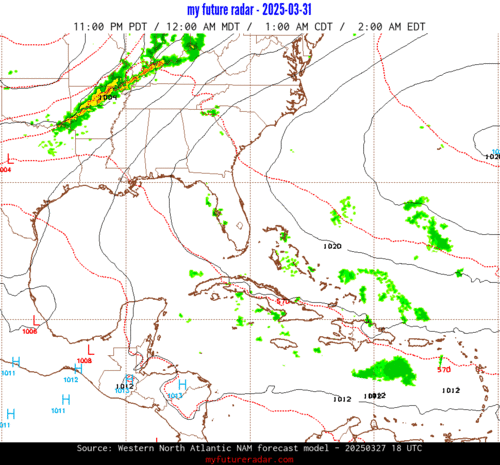
(above image is an example of the Western North Atlantic page - see Atlantic future radar page for a full set of images)
If a tropical storm or hurricane is threatening land, you can check my future radar for an idea of what radar might look like as the storm approaches.
SIX Land Hazards
NWS Local Hurricane Statements
- No warnings
SIX Tracker
SIX Satellite Loop
SIX Alternate Tracking Map
SIX Spaghetti Models
Spaghetti models for SIX can be found here:
SIX Watches and Warnings

Tropical Depression SIX Tropical Cyclone Update
Tropical Depression SIX Public Advisory
854
WTNT31 KNHC 200237
TCPAT1

BULLETIN
Tropical Depression Six Advisory Number   3
NWS National Hurricane Center Miami FL       AL062026
300 AM GMT Sun Sep 20 2026

...TROPICAL DEPRESSION HAS NOT STRENGTHENED AS IT MOVES SLOWLY
NORTH-NORTHEASTWARD...


SUMMARY OF 300 AM GMT...0300 UTC...INFORMATION
----------------------------------------------
LOCATION...33.3N 33.2W
ABOUT 475 MI...765 KM SW OF THE AZORES
MAXIMUM SUSTAINED WINDS...35 MPH...55 KM/H
PRESENT MOVEMENT...NNE OR 20 DEGREES AT 5 MPH...7 KM/H
MINIMUM CENTRAL PRESSURE...1007 MB...29.74 INCHES


WATCHES AND WARNINGS
--------------------
There are no coastal watches or warnings in effect.


DISCUSSION AND OUTLOOK
----------------------
At 300 AM GMT (0300 UTC), the center of Tropical Depression Six was
located near latitude 33.3 North, longitude 33.2 West. The
depression is moving toward the north-northeast near 5 mph (7 km/h).
The depression is expected to generally move to the northeast
through Sunday before turning eastward Sunday night.  A
southwestward motion is expected to start on Monday.

Recent satellite wind data indicate that maximum sustained winds
are near 35 mph (55 km/h) with higher gusts. Some strengthening is
possible during the next 24 hours, and the depression is expected
to become a tropical storm on Sunday. A weakening trend is expected
to begin by Monday.

The estimated minimum central pressure is 1007 mb (29.74 inches).


HAZARDS AFFECTING LAND
----------------------
None


NEXT ADVISORY
-------------
Next complete advisory at 900 AM GMT.

$$
Forecaster Beven
Public Advisory not available for this storm.
Tropical Depression SIX Forecast Discussion
742
WTNT41 KNHC 200237
TCDAT1

Tropical Depression Six Discussion Number   3
NWS National Hurricane Center Miami FL       AL062026
300 AM GMT Sun Sep 20 2026

The convective organization of the depression has increased
somewhat since the last advisory, with multiple convective bands in
the northern semicircle. This increase is reflected in the various
subjective and objective satellite intensity estimates now
suggesting the cyclone has reached tropical storm strength.
However, an ASCAT-C overpass showed maximum winds near 30 kt. Based
mainly on that the initial intensity will remain 30 kt.  Cirrus
cloud motion indicate that an upper-level cyclonic shear axis is
located near or just south of the center, with very strong
upper-level westerly flow over the southern part of the low-level
circulation.

The initial motion is 020/4 kt.  The depression is in an area of
weak steering currents between a low- to mid-level ridge to the
east and a deep-layer mid-latitude trough to the northwest. During
the next couple of days, the southern portion of this trough is
expected to weaken, with a low- to mid-level ridge developing to
the west and northwest of the tropical cyclone. This should result
in the cyclone stopping its north-northeastward motion and turning
toward the southwest. A general southwestward motion is then likely
until the system dissipates. The track guidance has shifted a bit
westward after 36 h, and the new forecast track is also nudged a
bit west of the previous track.

The dynamical models are forecasting a small upper-level low to
develop along the cyclonic shear axis near or south of the tropical
depression during the next 12 h or so. This is likely create a less
hostile shear environment around the depression that should allow
some intensification. After 24 h, the models are in good agreement
that strong upper-level northerly or northwesterly winds will move
over the cyclone, creating strong shear and causing weakening.
While the models forecast the shear to diminish after 48-60 h, the
cyclone or its remnants will be in an area of dry air and
subsidence that cause cause the convection to dissipate.  The new
intensity forecast shows the depression becoming a tropical storm
for a day or so, followed by weakening to a remnant low between
60-72 h. Based on the dynamical models, the remnant low is forecast
to weaken to a trough between 96-120 h.


FORECAST POSITIONS AND MAX WINDS

INIT  20/0300Z 33.3N  33.2W   30 KT  35 MPH
 12H  20/1200Z 33.8N  33.0W   40 KT  45 MPH
 24H  21/0000Z 34.0N  32.5W   45 KT  50 MPH
 36H  21/1200Z 33.6N  32.4W   40 KT  45 MPH
 48H  22/0000Z 32.7N  32.9W   35 KT  40 MPH
 60H  22/1200Z 31.6N  33.9W   30 KT  35 MPH
 72H  23/0000Z 30.4N  35.6W   25 KT  30 MPH...POST-TROP/REMNT LOW
 96H  24/0000Z 29.0N  39.1W   20 KT  25 MPH...POST-TROP/REMNT LOW
120H  25/0000Z...DISSIPATED

$$
Forecaster Beven
SIX storm path from NHC
| Time | Speed | Location | Status |
|---|---|---|---|
| 30 knots | 33.3, -33.2 | ||
| 40 knots | 33.8, -33.0 | ||
| 45 knots | 34.0, -32.5 | ||
| 40 knots | 33.6, -32.4 | ||
| 35 knots | 32.7, -32.9 | ||
| 30 knots | 31.6, -33.9 | ||
| 25 knots | 30.4, -35.6 | POST-TROPICAL CYCLONE | |
| 20 knots | 29.0, -39.1 | POST-TROPICAL CYCLONE | |
| 0 knots | DISSIPATED |
site by Hayley Croft
Hi, I'm Hayley. Did you know that I run this site out of my own pocket? So if you'd like to help support this site:
- Tell your friends about Cyclocane
- Buy something through this Amazon Cyclocane link
- make a donation - totally optional but completely appreciated
Make a monthly donation or a one-time donation to help support ongoing costs with Cyclocane.
Play solitaire and track all of the cyclocane storms at the same time at Hurricane Solitaire.