Cyclocane
( cyclocane is a CYCLOne and hurriCANE tracker by hayley )


English Español Deutsch Français 日本語
This is the final warning / advisory for this storm as it has weakened below warning levels and/or the storm system is no longer a tropical cyclone.
RINA Current Status
Current Wind Speed 25 knots / 30 MPH
Max Predicted Wind Speed 25 knots / 30 MPH at

Current Watches/Warnings / Radar / Satellite
current US watches/warnings

live tornado/thunderstorm tracker - tornadohq
future radar imagery - my future radar

future radar imagery

(above image is an example of the Western North Atlantic page - see Atlantic future radar page for a full set of images)
If a tropical storm or hurricane is threatening land, you can check my future radar for an idea of what radar might look like as the storm approaches.
RINA Land Hazards
NWS Local Hurricane Statements
- No warnings
RINA Tracker
RINA Satellite Loop
RINA Alternate Tracking Map
RINA Spaghetti Models
Spaghetti models for RINA can be found here:
RINA Watches and Warnings
Post-Tropical Cyclone RINA Tropical Cyclone Update
Post-Tropical Cyclone RINA Public Advisory
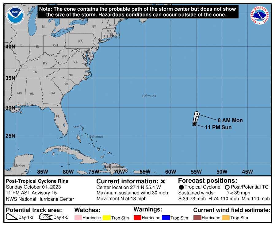
000
WTNT33 KNHC 020237
TCPAT3

BULLETIN
Post-Tropical Cyclone Rina Advisory Number  15
NWS National Hurricane Center Miami FL       AL182023
1100 PM AST Sun Oct 01 2023

...DEPRESSION BECOMES A REMNANT LOW...
...THIS IS THE LAST ADVISORY...


SUMMARY OF 1100 PM AST...0300 UTC...INFORMATION
-----------------------------------------------
LOCATION...27.1N 55.4W
ABOUT 785 MI...1265 KM NE OF THE NORTHERN LEEWARD ISLANDS
MAXIMUM SUSTAINED WINDS...30 MPH...45 KM/H
PRESENT MOVEMENT...N OR 10 DEGREES AT 13 MPH...20 KM/H
MINIMUM CENTRAL PRESSURE...1010 MB...29.83 INCHES


WATCHES AND WARNINGS
--------------------
There are no coastal watches or warnings in effect.


DISCUSSION AND OUTLOOK
----------------------
At 1100 PM AST (0300 UTC), the center of Post-Tropical Cyclone Rina
was located near latitude 27.1 North, longitude 55.4 West. The
post-tropical cyclone is moving toward the north near 13 mph (20
km/h), and this general motion is expected to continue through
Monday.

Maximum sustained winds have decreased to near 30 mph (45 km/h)
with higher gusts. The post-tropical remnant low is expected to
dissipate on Monday.

The estimated minimum central pressure is 1010 mb (29.83 inches).


HAZARDS AFFECTING LAND
----------------------
None.


NEXT ADVISORY
-------------
This is the last public advisory issued by the National Hurricane
Center on this system.  Additional information on this system can
be found in High Seas Forecasts issued by the National Weather
Service, under AWIPS header NFDHSFAT1, WMO header FZNT01 KWBC, and
online at ocean.weather.gov/shtml/NFDHSFAT1.php

$$
Forecaster Roberts
Public Advisory not available for this storm.
Post-Tropical Cyclone RINA Forecast Discussion
000
WTNT43 KNHC 020241
TCDAT3

Post-Tropical Cyclone Rina Discussion Number  15
NWS National Hurricane Center Miami FL       AL182023
1100 PM AST Sun Oct 01 2023

The depression's surface circulation has become increasingly diffuse
this evening while the cyclone has been devoid of organized deep
convection for over 18 hours.  Only a few small intermittent bursts
of convection have been present just to the east and south of the
center during the past couple of hours. Therefore, this is the final
advisory on Rina, and the system is now considered to be a
post-tropical remnant low and is likely to open up into a surface
trough on Monday.

The initial motion of the low-level cloud swirl is moving
northward, or 010/11 kt, and this general motion should continue
until the remnants of Rina completely dissipate over the central
subtropical Atlantic.


FORECAST POSITIONS AND MAX WINDS

INIT  02/0300Z 27.1N  55.4W   25 KT  30 MPH...POST-TROP/REMNT LOW
 12H  02/1200Z 28.9N  54.9W   25 KT  30 MPH...POST-TROP/REMNT LOW
 24H  03/0000Z...DISSIPATED

$$
Forecaster Roberts
RINA storm path from NHC
| Time | Speed | Location | Status |
|---|---|---|---|
| 25 knots | 27.1, -55.4 | POST-TROPICAL CYCLONE | |
| 25 knots | 28.9, -54.9 | POST-TROPICAL CYCLONE | |
| 0 knots | translation missing: en.DISSIPATED |
site by Hayley Croft
- Tell your friends about Cyclocane
- make a donation - totally optional but completely appreciated
Make a monthly donation or a one-time donation to help support ongoing costs with Cyclocane.
Play solitaire and track all of the cyclocane storms at the same time at Hurricane Solitaire.