Cyclocane
( cyclocane is a CYCLOne and hurriCANE tracker by hayley )
English Español Deutsch Français 日本語
This storm is unnamed. If the information appears to be out of date, its name may have changed, so visit the main page for the latest information.
PTC-THIRTEEN Current Status
Current Wind Speed 30 knots / 35 MPH
Max Predicted Wind Speed 75 knots / 85 MPH at

Current Watches/Warnings / Radar / Satellite
current US watches/warnings

live tornado/thunderstorm tracker - tornadohq
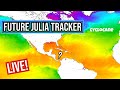
future radar imagery - my future radar

future radar imagery

(above image is an example of the Western North Atlantic page - see Atlantic future radar page for a full set of images)
If a tropical storm or hurricane is threatening land, you can check my future radar for an idea of what radar might look like as the storm approaches.
PTC-THIRTEEN Land Hazards
NWS Local Hurricane Statements
- No warnings
- WIND - Hurricane conditions are possible on the Colombian islands of San Andres, Providencia, and Santa Catalina Saturday night, with tropical storm conditions possible by Saturday afternoon.
- RAINFALL - Potential Tropical Cyclone Thirteen is expected to produce the following rain accumulations through early Monday:
- STORM SURGE - A storm surge could raise water levels by as much as 1 to 3 feet above normal tide levels along the immediate coast in areas of onshore winds on San Andres, Providencia, and Santa Catalina Islands. Near the coast, the surge will be accompanied by large and damaging waves.
- SURF - Swells generated by disturbance will affect the ABC Islands and portions of the coasts of northwestern Venezuela and the Guajira Peninsula of Colombia through Friday. Swells could reach Jamaica, Providencia, and San Andres on Saturday, and portions of the coast of Central America on Sunday. These swells are likely to cause life-threatening surf and rip current conditions. Please consult products from your local weather office.
PTC-THIRTEEN Tracker
PTC-THIRTEEN Satellite Loop
PTC-THIRTEEN Alternate Tracking Map
PTC-THIRTEEN Spaghetti Models
Spaghetti models for PTC-THIRTEEN can be found here:
PTC-THIRTEEN spaghetti models page »
PTC-THIRTEEN Watches and Warnings

Potential Tropical Cyclone PTC-THIRTEEN Tropical Cyclone Update
Potential Tropical Cyclone PTC-THIRTEEN Public Advisory
000
WTNT33 KNHC 062337
TCPAT3

BULLETIN
Potential Tropical Cyclone Thirteen Intermediate Advisory Number 2A
NWS National Hurricane Center Miami FL       AL132022
800 PM AST Thu Oct 06 2022

...AIR FORCE RESERVE HURRICANE HUNTER AIRCRAFT CURRENTLY
SURVEYING THE DISTURBANCE...
...HEAVY RAINS EXPECTED ACROSS THE ABC ISLANDS AND PORTIONS OF
NORTHERN SOUTH AMERICA THROUGH FRIDAY...


SUMMARY OF 800 PM AST...0000 UTC...INFORMATION
----------------------------------------------
LOCATION...11.7N 69.1W
ABOUT 35 MI...55 KM SSW OF CURACAO
ABOUT 175 MI...280 KM ESE OF NTHRN TIP OF GUAJIRA PNSULA COLOMBIA
MAXIMUM SUSTAINED WINDS...35 MPH...55 KM/H
PRESENT MOVEMENT...W OR 270 DEGREES AT 17 MPH...28 KM/H
MINIMUM CENTRAL PRESSURE...1003 MB...29.62 INCHES


WATCHES AND WARNINGS
--------------------
CHANGES WITH THIS ADVISORY:

None.

SUMMARY OF WATCHES AND WARNINGS IN EFFECT:

A Hurricane Watch is in effect for...
* San Andres, Providencia, and Santa Catalina Islands Colombia

A Tropical Storm Warning is in effect for...
* Coast of Colombia from Riohacha eastward to the Colombia/Venezuela
border

A Hurricane Watch means that hurricane conditions are possible
within the watch area.  A watch is typically issued 48 hours
before the anticipated first occurrence of tropical-storm-force
winds, conditions that make outside preparations difficult or
dangerous.

A Tropical Storm Warning means that tropical storm conditions are
expected somewhere within the warning area, in this case within
the next 12 to 24 hours.

Interests along the coasts of Nicaragua and Honduras should monitor
the progress of the disturbance.  Additional watches or warnings
could be required tonight or on Friday.

For storm information specific to your area, please monitor
products issued by your national meteorological service.


DISCUSSION AND OUTLOOK
----------------------
At 800 PM AST (0000 UTC), the disturbance was centered near latitude
11.7 North, longitude 69.1 West.  The system is moving toward the
west near 17 mph (28 km/h), and this general motion is expected to
continue through Sunday.  On the forecast track, the system is
expected to move near the ABC Islands, the coast of northwestern
Venezuela, and the Guajira Peninsula of Colombia through Friday
morning.  The system is then forecast to move across the
southwestern Caribbean Sea, moving near San Andres and Providencia
Islands Saturday night, and approaching the coast of Nicaragua on
Sunday.

Maximum sustained winds are near 35 mph (55 km/h) with higher
gusts. Strengthening is forecast during the next few days.  The
system is expected to become a tropical depression or tropical storm
later tonight.  The system is then expected to become a hurricane by
Saturday night as it approaches the coast of Nicaragua.
* Formation chance through 48 hours...high...near 100 percent.
* Formation chance through 5 days...high...near 100 percent.

The estimated minimum central pressure is 1003 mb (29.62 inches)
based on observations from Bonaire, Curacao, and the Hurricane
Hunter aircraft.


HAZARDS AFFECTING LAND
----------------------
WIND:  Hurricane conditions are possible on the Colombian islands of
San Andres, Providencia, and Santa Catalina Saturday night, with
tropical storm conditions possible by Saturday afternoon.

Tropical storm conditions are expected along the coast of Colombia
within the warning area by early Friday.  Gusts to tropical
storm force are also possible across the ABC Islands and the
northwestern coast of Venezuela today and tonight.

RAINFALL:  Potential Tropical Cyclone Thirteen is expected to
produce the following rain accumulations through early Monday:

Northern Coastal Venezuela...3 to 6 inches, isolated 10 inches.
Aruba, Bonaire, and Curacao...3 to 6 inches
Guajira Peninsula...3 to 6 inches, isolated 10 inches.
San Andres and Providencia...6 to 12 inches
Eastern Nicaragua...6 to 10 inches, isolated 16 inches.
Central Nicaragua...3 to 6 inches, isolated 10 inches.
Southwest Costa Rica and Extreme Western Panama...4 to 8 inches,
isolated 12 inches

This rainfall may cause life-threatening flash floods.  There is
also the potential for life-threatening mudslides across portions of
Central America this weekend.

STORM SURGE:  A storm surge could raise water levels by as much as
1 to 3 feet above normal tide levels along the immediate coast in
areas of onshore winds on San Andres, Providencia, and Santa
Catalina Islands.  Near the coast, the surge will be accompanied by
large and damaging waves.

SURF:  Swells generated by disturbance will affect the ABC Islands
and portions of the coasts of northwestern Venezuela and the Guajira
Peninsula of Colombia through Friday.  Swells could reach Jamaica,
Providencia, and San Andres on Saturday, and portions of the coast
of Central America on Sunday.  These swells are likely to cause
life-threatening surf and rip current conditions.  Please consult
products from your local weather office.


NEXT ADVISORY
-------------
Next complete advisory at 1100 PM AST.

$$
Forecaster Beven
Public Advisory not available for this storm.
Potential Tropical Cyclone PTC-THIRTEEN Forecast Discussion
000
WTNT43 KNHC 062037
TCDAT3

Potential Tropical Cyclone Thirteen Discussion Number   2
NWS National Hurricane Center Miami FL       AL132022
500 PM AST Thu Oct 06 2022

The disturbance is gradually becoming better organized, with some
convective banding attempting to form west of the center during the
past several hours.  Radar imagery from Curacao also suggests there
could be a better-defined center trying to form just to the south
of Bonaire and Curacao, but there are not enough nearby surface
observations to confirm that.  Therefore, the system is not yet
designated as a tropical depression.  However, an Air Force
Reserve Hurricane Hunter aircraft scheduled for a survey mission
later this evening should hopefully give us a better sense of the
wind field and help provide evidence if the system has developed a
well-defined circulation.

The track forecast is straightforward.  The disturbance is being
driven quickly westward with a motion of 270/15 kt by a strong low-
to mid-level ridge stretching across the western Atlantic and Gulf
of Mexico.  This feature should maintain the system on a westward
heading for the next 3 days across the southwestern Caribbean Sea,
with some slowing of the forward motion as it moves away from the
main high center over the western Atlantic.  A slight turn toward
the west-northwest across Central America is forecast by day 4 once
the system, or its remnants, reaches the western periphery of the
ridge.  The track models remain tightly clustered, and the new NHC
forecast is near the previous prediction and the TVCN/HCCA
consensus aids.

The system is likely to form a well-defined center and become a
tropical cyclone within the next 6-12 hours, which is generally
shown by the various global models.  They, along with
statistical-dynamical guidance, indicate the system should also
begin to gradually strengthen while passing near the Guajira
Peninsula of Colombia.  Once the system reaches the southwestern
Caribbean Sea, low to moderate shear and warm sea surface
temperatures of 29 to 30 degrees Celsius should foster faster
strengthening, and a consensus of the various SHIPS Rapid
Intensification (RI) indices indicates a 65-75 percent chance of a
65-kt increase over the next 3 days.  The NHC intensity is not yet
that aggressive, but the peak intensity now shown in the official
forecast is raised a bit higher to 75 kt at 60 and 72 hours.  It's
possible that the intensity could get a little higher between those
times before the system reaches land.  Based on the forecast track,
the system is unlikely to survive a trek across the terrain of
Central America, and dissipation is therefore shown by day 5.


Key Messages:

1. Tropical storm conditions are expected across portions of the
Guajira Peninsula of Colombia tonight and early Friday, where a
Tropical Storm Warning has been issued.  Gusts to tropical storm
force are possible across portions of northern Venezuela, Aruba,
Curacao, and Bonaire through early Friday.

2. The system is expected to strengthen when it moves over the
southwestern Caribbean Sea, and a Hurricane Watch is in effect for
San Andres, Providencia, and Santa Catalina Islands.  Interests in
Nicaragua and Honduras should also monitor the system's
progress, and additional watches or warnings could be required for
portions of these areas tonight or on Friday

3. Heavy rainfall could cause life-threatening flash flooding over
portions of the Guajira Peninsula of Colombia, northern Venezuela,
and the island chain of Aruba, Bonaire and Curacao during the next
day or two.  Heavy rains and the potential for flash flooding and
mudslides are expected to spread to portions of Central America this
weekend.


FORECAST POSITIONS AND MAX WINDS

INIT  06/2100Z 11.6N  68.7W   30 KT  35 MPH...POTENTIAL TROP CYCLONE
 12H  07/0600Z 12.0N  70.7W   35 KT  40 MPH...TROPICAL STORM
 24H  07/1800Z 12.6N  73.6W   40 KT  45 MPH
 36H  08/0600Z 13.0N  76.7W   50 KT  60 MPH
 48H  08/1800Z 13.0N  79.6W   60 KT  70 MPH
 60H  09/0600Z 13.1N  81.9W   75 KT  85 MPH
 72H  09/1800Z 13.3N  84.1W   75 KT  85 MPH...INLAND
 96H  10/1800Z 14.8N  89.1W   35 KT  40 MPH...INLAND
120H  11/1800Z...DISSIPATED

$$
Forecaster Berg
PTC-THIRTEEN storm path from NHC
| Time | Speed | Location | Status |
|---|---|---|---|
| 30 knots | 11.7, -69.1 | ||
| 35 knots | 12.0, -70.7 | TROPICAL STORM | |
| 40 knots | 12.6, -73.6 | ||
| 50 knots | 13.0, -76.7 | ||
| 60 knots | 13.0, -79.6 | ||
| 75 knots | 13.1, -81.9 | ||
| 75 knots | 13.3, -84.1 | translation missing: en.INLAND | |
| 35 knots | 14.8, -89.1 | translation missing: en.INLAND | |
| 0 knots | translation missing: en.DISSIPATED |
site by Hayley Croft
- Tell your friends about Cyclocane
- make a donation - totally optional but completely appreciated
Make a monthly donation or a one-time donation to help support ongoing costs with Cyclocane.
Play solitaire and track all of the cyclocane storms at the same time at Hurricane Solitaire.