Cyclocane
( cyclocane is a CYCLOne and hurriCANE tracker by hayley )


English Español Deutsch Français 日本語
This storm is unnamed. If the information appears to be out of date, its name may have changed, so visit the main page for the latest information.
PTC-FIVE Current Status
Current Wind Speed 30 knots / 35 MPH
Max Predicted Wind Speed 95 knots / 110 MPH at
Current Watches/Warnings / Radar / Satellite
current US watches/warnings

live tornado/thunderstorm tracker - tornadohq
future radar imagery - my future radar

future radar imagery

(above image is an example of the Western North Atlantic page - see Atlantic future radar page for a full set of images)
If a tropical storm or hurricane is threatening land, you can check my future radar for an idea of what radar might look like as the storm approaches.
PTC-FIVE Land Hazards
- RAINFALL - Potential Tropical Cyclone Five is expected to produce total rain accumulations of 4 to 6 inches over portions of the Leeward and Virgin Islands. For Puerto Rico, 3 to 6 inches of rainfall, with maximum amounts of 10 inches, is expected.
- WIND - Tropical storm conditions are expected in the warning area for the Leeward Islands beginning late tonight or early Tuesday. Tropical storm conditions are expected to begin spreading over the Virgin Islands and Puerto Rico on Tuesday night or early Wednesday.
- STORM SURGE - A storm surge will raise water levels by as much as 1 to 3 feet above ground level for the eastern coast of Puerto Rico from San Juan to Guayama, including the islands of Culebra and Vieques and in the U.S. Virgin Islands, including St. Thomas, St. John, and St. Croix.
- SURF - Swells generated by the system will likely begin to affect portions of the Leeward Islands beginning tonight. These swells are likely to cause life-threatening surf and rip current conditions. Please consult products from your local weather office.
PTC-FIVE Tracker
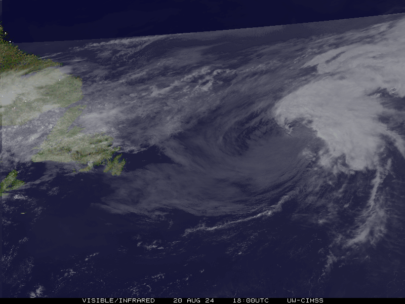
PTC-FIVE Satellite Loop
PTC-FIVE Alternate Tracking Map
PTC-FIVE Spaghetti Models
Spaghetti models for PTC-FIVE can be found here:
PTC-FIVE spaghetti models page »
PTC-FIVE Watches and Warnings

Potential Tropical Cyclone PTC-FIVE Tropical Cyclone Update
Potential Tropical Cyclone PTC-FIVE Public Advisory
000
WTNT35 KNHC 121746
TCPAT5

BULLETIN
Potential Tropical Cyclone Five Intermediate Advisory Number 4A
NWS National Hurricane Center Miami FL       AL052024
200 PM AST Mon Aug 12 2024

...AIR FORCE HURRICANE HUNTERS INVESTIGATING THE SYSTEM...
...TROPICAL STORM CONDITIONS AND HEAVY RAIN EXPECTED IN PORTIONS OF
THE LEEWARD ISLANDS LATE TONIGHT OR EARLY TUESDAY...

SUMMARY OF 200 PM AST...1800 UTC...INFORMATION
----------------------------------------------
LOCATION...15.5N 56.4W
ABOUT 375 MI...600 KM ESE OF ANTIGUA
ABOUT 670 MI...1080 KM ESE OF SAN JUAN PUERTO RICO
MAXIMUM SUSTAINED WINDS...35 MPH...55 KM/H
PRESENT MOVEMENT...W OR 280 DEGREES AT 26 MPH...43 KM/H
MINIMUM CENTRAL PRESSURE...1010 MB...29.83 INCHES


WATCHES AND WARNINGS
--------------------
CHANGES WITH THIS ADVISORY:

None

SUMMARY OF WATCHES AND WARNINGS IN EFFECT:

A Tropical Storm Warning is in effect for...
* St. Kitts, Nevis, Montserrat, Antigua, Barbuda, and Anguilla
* Guadeloupe
* St. Martin and St. Barthelemy
* Sint Maarten
* British Virgin Islands
* U.S. Virgin Islands
* Puerto Rico
* Vieques
* Culebra

A Tropical Storm Warning means that tropical storm conditions are
expected somewhere within the warning area within 36 hours.

Interests elsewhere in the northeastern Caribbean should monitor the
progress of Potential Tropical Cyclone Five.

For storm information specific to your area in the United
States, including possible inland watches and warnings, please
monitor products issued by your local National Weather Service
forecast office. For storm information specific to your area
outside of the United States, please monitor products issued by
your national meteorological service.


DISCUSSION AND OUTLOOK
----------------------
At 200 PM AST (1800 UTC), the disturbance was centered near latitude
15.5 North, longitude 56.4 West. The system is moving toward the
west near 26 mph (43 km/h). A westward to west-northwestward motion
with some decrease in forward speed is expected during the next
couple of days. On the forecast track, the disturbance is expected
to move across portions of the Leeward Islands late tonight or
Tuesday and approach the U.S. and British Virgin Islands and Puerto
Rico Tuesday evening. Then, the disturbance is forecast to move away
from Puerto Rico over the western Atlantic through midweek.

Maximum sustained winds are near 35 mph (55 km/h) with higher
gusts. Gradual strengthening is forecast during the next couple of
days, and the disturbance is expected to become a tropical
depression later today or tonight and become a tropical storm as it
nears the Leeward Islands.
* Formation chance through 48 hours... high...near 100 percent.
* Formation chance through 7 days...high...near 100 percent.

The estimated minimum central pressure is 1010 mb (29.83 inches).


HAZARDS AFFECTING LAND
----------------------
Key messages for Potential Tropical Cyclone Five can be found in
the Tropical Cyclone Discussion under AWIPS header MIATCDAT5 and WMO
header WTNT45 KNHC and on the web at
hurricanes.gov/text/MIATCDAT5.shtml.

RAINFALL: Potential Tropical Cyclone Five is expected to produce
total rain accumulations of 4 to 6 inches over portions of the
Leeward and Virgin Islands. For Puerto Rico, 3 to 6 inches of
rainfall, with maximum amounts of 10 inches, is expected.

Elsewhere in the Caribbean, Potential Tropical Cyclone Five is
expected to produce the following rain accumulations through Friday
morning:
Windward Islands...1 to 4 inches
Eastern Hispaniola...2 to 4 inches

For a complete depiction of forecast rainfall associated with
Potential Tropical Cyclone Five, please see the National Weather
Service Storm Total Rainfall Graphic, available at
hurricanes.gov/graphics_at5.shtml?rainqpf

WIND:  Tropical storm conditions are expected in the warning area
for the Leeward Islands beginning late tonight or early Tuesday.
Tropical storm conditions are expected to begin spreading over the
Virgin Islands and Puerto Rico on Tuesday night or early Wednesday.

STORM SURGE: A storm surge will raise water levels by as much as 1
to 3 feet above ground level for the eastern coast of Puerto Rico
from San Juan to Guayama, including the islands of Culebra and
Vieques and in the U.S. Virgin Islands, including St. Thomas, St.
John, and St. Croix.

A storm surge will raise water levels by as much as 1 to 3 feet
above normal tide levels in the British Virgin Islands. Near the
coast, the surge will be accompanied by large and destructive waves.

SURF:  Swells generated by the system will likely begin to affect
portions of the Leeward Islands beginning tonight. These swells are
likely to cause life-threatening surf and rip current conditions.
Please consult products from your local weather office.


NEXT ADVISORY
-------------
Next complete advisory at 500 PM AST.

$$
Forecaster Cangialosi/Hagen
Public Advisory not available for this storm.
Potential Tropical Cyclone PTC-FIVE Forecast Discussion
836
WTNT45 KNHC 121456
TCDAT5

Potential Tropical Cyclone Five Discussion Number   4
NWS National Hurricane Center Miami FL       AL052024
1100 AM AST Mon Aug 12 2024

Data from the NOAA Hurricane Hunter aircraft investigating the storm
indicate a low-level center could be attempting to form closer to
some increased convective activity within the northern semicircle of
the disturbance. While the disturbance appears to be gradually
becoming better organized in satellite imagery, the lack of a
well-defined center means it will remain a potential tropical
cyclone for this advisory. Based on the flight-level winds and some
distant scatterometer data over the eastern part of the circulation,
the initial intensity is set at 30 kt. An Air Force Reserve
Hurricane Hunter aircraft will investigate the system this afternoon
and help us assess any changes to the low-level wind field.

Overall, the disturbance has moved a little faster to the west than
previous estimates, and the initial motion remains quickly westward
(280/23 kt). A westward to west-northwestward motion with some
decrease in forward speed is expected during the next couple of days
while the system moves around the southwestern extent of the
subtropical ridge. This will bring the center over portions of the
Leeward Islands late tonight into Tuesday, and then near or over the
Virgin Islands and Puerto Rico late Tuesday night and Wednesday. By
midweek, the system will reach a weakness in the mid-level ridge
caused by a mid-latitude trough moving across the western Atlantic.
This should induce a northwestward to northward motion during the
latter half of the forecast period. The track guidance envelope has
shifted to the left of the previous track, likely a product of the
faster forward speed and the weaker initial state of the system.
Only small adjustments were made to the near-term NHC track
forecast, with a slightly larger westward adjustment at days 3-5.

Until the disturbance becomes better organized, the large radius of
maximum wind and some northeasterly shear should only allow for
modest strengthening during the next 24-48 h. The NHC forecast shows
it becoming a tropical storm in 24 h and continuing to slowly
strengthen while it passes over the northeastern Caribbean Sea. Once
the system reaches the western Atlantic, the intensity guidance
favors more significant strengthening, and the system is forecast to
become a hurricane in 3 days and continue intensifying thereafter.
No major changes were made to the NHC intensity forecast this cycle,
which remains close to the multi-model consensus.


Key Messages:

1. The disturbance is expected to become a tropical storm as it
reaches the Leeward Islands. Tropical Storm Warnings are in effect
for most of these islands, where tropical storm conditions
are expected to begin late tonight.

2. Heavy rainfall may result in locally considerable flash flooding
and mudslides in areas of the Leeward and Virgin Islands by later
today into Wednesday, and over Puerto Rico late Tuesday into
Thursday.

3. A Tropical Storm Warning is now in effect for the Virgin Islands
and Puerto Rico, where tropical storm conditions are expected to
begin Tuesday night or early Wednesday.


FORECAST POSITIONS AND MAX WINDS

INIT  12/1500Z 15.1N  55.6W   30 KT  35 MPH...POTENTIAL TROP CYCLONE
 12H  13/0000Z 15.5N  58.8W   35 KT  40 MPH...POTENTIAL TROP CYCLONE
 24H  13/1200Z 16.3N  62.2W   35 KT  40 MPH
 36H  14/0000Z 17.3N  64.6W   40 KT  45 MPH
 48H  14/1200Z 18.8N  66.4W   45 KT  50 MPH
 60H  15/0000Z 20.5N  67.6W   55 KT  65 MPH
 72H  15/1200Z 22.7N  68.2W   65 KT  75 MPH
 96H  16/1200Z 27.0N  67.5W   85 KT 100 MPH
120H  17/1200Z 31.5N  65.0W   95 KT 110 MPH

$$
Forecaster Reinhart
PTC-FIVE storm path from NHC
| Time | Speed | Location | Status |
|---|---|---|---|
| 30 knots | 15.5, -56.4 | ||
| 35 knots | 15.5, -58.8 | translation missing: en.POTENTIAL TROP CYCLONE | |
| 35 knots | 16.3, -62.2 | ||
| 40 knots | 17.3, -64.6 | ||
| 45 knots | 18.8, -66.4 | ||
| 55 knots | 20.5, -67.6 | ||
| 65 knots | 22.7, -68.2 | ||
| 85 knots | 27.0, -67.5 | ||
| 95 knots | 31.5, -65.0 |
site by Hayley Croft
Hi, I'm Hayley. Did you know that I run this site out of my own pocket? So if you'd like to help support this site:
- Tell your friends about Cyclocane
- Buy something through this Amazon Cyclocane link
- make a donation - totally optional but completely appreciated
Make a monthly donation or a one-time donation to help support ongoing costs with Cyclocane.
Play solitaire and track all of the cyclocane storms at the same time at Hurricane Solitaire.