Cyclocane
( cyclocane is a CYCLOne and hurriCANE tracker by hayley )


English Español Deutsch Français 日本語
KENNETH Current Status
...KENNETH TURNS NORTHWESTWARD... ...FORECAST TO DEGENERATE INTO A REMNANT LOW IN A COUPLE OF DAYS...
Current Wind Speed 45 knots / 50 MPH
Max Predicted Wind Speed 45 knots / 50 MPH at

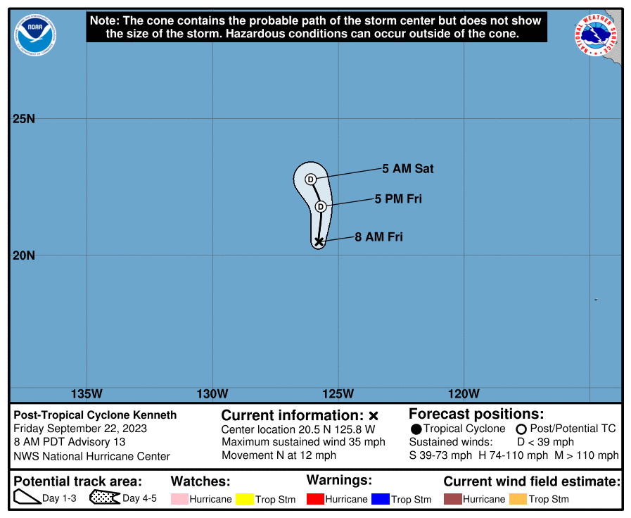
KENNETH Land Hazards
KENNETH Tracker
KENNETH Satellite Loop

KENNETH Alternate Tracking Map
KENNETH Spaghetti Models
Spaghetti models for KENNETH can be found here:
KENNETH spaghetti models page »
KENNETH Watches and Warnings
Tropical Storm KENNETH Tropical Cyclone Update
Tropical Storm KENNETH Public Advisory
000
WTPZ33 KNHC 210232
TCPEP3

BULLETIN
Tropical Storm Kenneth Advisory Number   7
NWS National Hurricane Center Miami FL       EP132023
800 PM PDT Wed Sep 20 2023

...KENNETH TURNS NORTHWESTWARD...
...FORECAST TO DEGENERATE INTO A REMNANT LOW IN A COUPLE OF DAYS...


SUMMARY OF 800 PM PDT...0300 UTC...INFORMATION
----------------------------------------------
LOCATION...16.9N 125.2W
ABOUT 1075 MI...1730 KM WSW OF THE SOUTHERN TIP OF BAJA CALIFORNIA
MAXIMUM SUSTAINED WINDS...50 MPH...85 KM/H
PRESENT MOVEMENT...NW OR 310 DEGREES AT 12 MPH...19 KM/H
MINIMUM CENTRAL PRESSURE...1000 MB...29.53 INCHES


WATCHES AND WARNINGS
--------------------
There are no coastal watches or warnings in effect.


DISCUSSION AND OUTLOOK
----------------------
At 800 PM PDT (0300 UTC), the center of Tropical Storm Kenneth was
located near latitude 16.9 North, longitude 125.2 West.  Kenneth is
moving toward the northwest near 12 mph (19 km/h).  A turn toward
the north-northwest and north at a slightly slower forward speed is
expected Thursday and Thursday night.  A northward motion is
forecast to continue through Saturday.

Maximum sustained winds are near 50 mph (85 km/h) with higher gusts.
Weakening is forecast to begin on Thursday.  Kenneth could
degenerate into a remnant low by late Friday.

Tropical-storm-force winds extend outward up to 80 miles (130 km)
from the center.

The estimated minimum central pressure is 1000 mb (29.53 inches).


HAZARDS AFFECTING LAND
----------------------
None


NEXT ADVISORY
-------------
Next complete advisory at 200 AM PDT.

$$
Forecaster Berg
Public Advisory not available for this storm.
Tropical Storm KENNETH Forecast Discussion
000
WTPZ43 KNHC 210232
TCDEP3

Tropical Storm Kenneth Discussion Number   7
NWS National Hurricane Center Miami FL       EP132023
800 PM PDT Wed Sep 20 2023

It appears that southerly mid-level shear has set in over Kenneth
during the day, and the surface center is now located on the
southern side of the ongoing convective mass.  Dvorak final-T
numbers are a consensus 3.0 from TAFB and SAB, so the initial
intensity remains 45 kt.

The shear appears to have pulled Kenneth's center farther to the
north, and as a result, the storm has turned northwestward with an
initial motion of 310/10 kt.  A turn toward the north-northwest and
north is expected over the next 36 hours as Kenneth moves around
the western periphery of the subtropical ridge.  Partly because of
the required adjustment of the initial position, the track guidance
has shifted significantly to the north and east on this cycle.  The
new NHC track forecast lies very close to the GFS, ECMWF, TVCE, and
HCCA aids, particularly during the first 36 hours of the forecast,
and is as much as 30-40 n mi to the right of the previous
prediction.

As is often the case, the mid-level shear affecting the cyclone was
not foreseen, as nearly all shear diagnostics show that the shear in
a deeper layer of the atmosphere is currently very low.  That said,
even the deep-layer shear is forecast to increase to
moderate-to-strong levels in the next 12-24 hours.  Simultaneously,
Kenneth will be moving over increasingly cooler waters that are less
than 26 degrees Celsius.  Therefore, weakening is expected to begin
by 24 hours, and strong shear and a drier, more stable atmosphere
should cause Kenneth to degenerate into a remnant low by late
Friday.  The remnant low could hang around for a few days, opening
up into a trough by Sunday.


FORECAST POSITIONS AND MAX WINDS

INIT  21/0300Z 16.9N 125.2W   45 KT  50 MPH
 12H  21/1200Z 17.6N 126.0W   45 KT  50 MPH
 24H  22/0000Z 19.0N 126.8W   40 KT  45 MPH
 36H  22/1200Z 20.7N 126.9W   35 KT  40 MPH
 48H  23/0000Z 22.1N 126.8W   30 KT  35 MPH...POST-TROP/REMNT LOW
 60H  23/1200Z 23.1N 126.8W   25 KT  30 MPH...POST-TROP/REMNT LOW
 72H  24/0000Z 23.8N 127.2W   25 KT  30 MPH...POST-TROP/REMNT LOW
 96H  25/0000Z...DISSIPATED

$$
Forecaster Berg
KENNETH storm path from NHC
| Time | Speed | Location | Status |
|---|---|---|---|
| 45 knots | 16.9, -125.2 | ||
| 45 knots | 17.6, -126.0 | ||
| 40 knots | 19.0, -126.8 | ||
| 35 knots | 20.7, -126.9 | ||
| 30 knots | 22.1, -126.8 | POST-TROPICAL CYCLONE | |
| 25 knots | 23.1, -126.8 | POST-TROPICAL CYCLONE | |
| 25 knots | 23.8, -127.2 | POST-TROPICAL CYCLONE | |
| 0 knots | translation missing: en.DISSIPATED |
site by Hayley Croft
Want to help support this site?
- Tell your friends about Cyclocane
- make a donation - totally optional but completely appreciated
Make a monthly donation or a one-time donation to help support ongoing costs with Cyclocane.
Play solitaire and track all of the cyclocane storms at the same time at Hurricane Solitaire.