Cyclocane
( cyclocane is a CYCLOne and hurriCANE tracker by hayley )
English Español Deutsch Français 日本語
This is the final warning / advisory for this storm as it has weakened below warning levels and/or the storm system is no longer a tropical cyclone.
HERMINE Current Status
Current Wind Speed 25 knots / 30 MPH
Max Predicted Wind Speed 25 knots / 30 MPH at

Current Watches/Warnings / Radar / Satellite
current US watches/warnings

live tornado/thunderstorm tracker - tornadohq
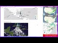
future radar imagery - my future radar

future radar imagery

(above image is an example of the Western North Atlantic page - see Atlantic future radar page for a full set of images)
If a tropical storm or hurricane is threatening land, you can check my future radar for an idea of what radar might look like as the storm approaches.
HERMINE Land Hazards
NWS Local Hurricane Statements
- No warnings
- RAINFALL - Hermine is expected to produce 3 to 6 (75 to 150 mm) inches of rainfall with localized higher amounts up to 10 inches (250 mm) across the Canary Islands through Monday. This rainfall may cause some flash flooding in areas of higher terrain.
HERMINE Tracker
HERMINE Satellite Loop
HERMINE Alternate Tracking Map
HERMINE Spaghetti Models
Spaghetti models for HERMINE can be found here:
HERMINE spaghetti models page »
HERMINE Watches and Warnings

Post-Tropical Cyclone HERMINE Tropical Cyclone Update
Post-Tropical Cyclone HERMINE Public Advisory
000
WTNT35 KNHC 250839
TCPAT5

BULLETIN
Post-Tropical Cyclone Hermine Advisory Number   8
NWS National Hurricane Center Miami FL       AL102022
800 AM CVT Sun Sep 25 2022

...HERMINE BECOMES A POST-TROPICAL REMNANT LOW...
...HEAVY RAINS EXPECTED TO CONTINUE ACROSS THE CANARY ISLANDS
THROUGH MONDAY...


SUMMARY OF 800 AM CVT...0900 UTC...INFORMATION
----------------------------------------------
LOCATION...23.6N 20.2W
ABOUT 580 MI...935 KM NNE OF THE CABO VERDE ISLANDS
MAXIMUM SUSTAINED WINDS...30 MPH...45 KM/H
PRESENT MOVEMENT...N OR 10 DEGREES AT 7 MPH...11 KM/H
MINIMUM CENTRAL PRESSURE...1008 MB...29.77 INCHES


WATCHES AND WARNINGS
--------------------
There are no coastal watches or warnings in effect.


DISCUSSION AND OUTLOOK
----------------------
At 800 AM CVT (0900 UTC), the center of Post-Tropical Cyclone
Hermine was located near latitude 23.6 North, longitude 20.2 West.
The post-tropical cyclone is moving toward the north near 7 mph (11
km/h) and this motion is expected to continue through Sunday
followed by a slow turn toward the northwest early Monday and a
turn to the west-northwest Monday evening.

Maximum sustained winds have decreased to near 30 mph (45 km/h)
with higher gusts.  Hermine is expected to dissipate in a couple of
days.

The estimated minimum central pressure is 1008 mb (29.77 inches).


HAZARDS AFFECTING LAND
----------------------
RAINFALL: Hermine is expected to produce 3 to 6 (75 to 150 mm)
inches of rainfall with localized higher amounts up to 10 inches
(250 mm) across the Canary Islands through Monday. This rainfall may
cause some flash flooding in areas of higher terrain.


NEXT ADVISORY
-------------
This is the last public advisory issued by the National Hurricane
Center on Hermine.  Additional information on Hermine can be
found in High Seas Forecasts issued by Meteo France under WMO
header FQNT50 LFPW and available on the web at
www.meteofrance.com/previsions-meteo-marine/bulletin/grandlarge/
metarea2.

$$
Forecaster Roberts
Public Advisory not available for this storm.
Post-Tropical Cyclone HERMINE Forecast Discussion
000
WTNT45 KNHC 250840
TCDAT5

Post-Tropical Cyclone Hermine Discussion Number   8
NWS National Hurricane Center Miami FL       AL102022
800 AM CVT Sun Sep 25 2022

Hermine's structure overnight has deteriorated further.  While
occasional intermittent bursts of deep convection are still
occurring to the north of the elongated surface circulation, this
convection lacks organization.  The system no longer meets the
definition of a tropical cyclone and, therefore, is being declared
a remnant low and this will be the last NHC advisory on Hermine.

Strong southwesterly shear greater than 40 kt and a high
statically stable surrounding Saharan air mass should prevent the
regeneration of organized convection during the next several days.
The global models and the statistical SHIPS intensity guidance
agree that the remnant low will open up into a trough of low
pressure Tuesday, and the official forecast follows suit.

The initial motion is estimated to be northward, or 010/6 kt. This
general motion is expected to continue today while the cyclone
moves around the western periphery of a mid-tropospheric ridge.
Beyond Monday morning, the remnant low is forecast to turn toward
the northwest and west-northwest in response to the above mention
ridge building westward over the extreme eastern tropical Atlantic.
The NHC forecast track is based on the various consensus aids and
is similar to the previous advisory.

Additional information on this system can be found in High Seas
Forecasts issued by Meteo France under WMO header FQNT50 LFPW and
available on the web at
www.meteofrance.com/previsions-meteo-marine/bulletin/grandlarge/
metarea2.


FORECAST POSITIONS AND MAX WINDS

INIT  25/0900Z 23.6N  20.2W   25 KT  30 MPH...POST-TROP/REMNT LOW
 12H  25/1800Z 24.3N  19.9W   25 KT  30 MPH...POST-TROP/REMNT LOW
 24H  26/0600Z 24.6N  20.1W   25 KT  30 MPH...POST-TROP/REMNT LOW
 36H  26/1800Z 24.9N  21.2W   20 KT  25 MPH...POST-TROP/REMNT LOW
 48H  27/0600Z...DISSIPATED

$$
Forecaster Roberts
HERMINE storm path from NHC
| Time | Speed | Location | Status |
|---|---|---|---|
| 25 knots | 23.6, -20.2 | POST-TROPICAL CYCLONE | |
| 25 knots | 24.3, -19.9 | POST-TROPICAL CYCLONE | |
| 25 knots | 24.6, -20.1 | POST-TROPICAL CYCLONE | |
| 20 knots | 24.9, -21.2 | POST-TROPICAL CYCLONE | |
| 0 knots | translation missing: en.DISSIPATED |
site by Hayley Croft
- Tell your friends about Cyclocane
- make a donation - totally optional but completely appreciated
Make a monthly donation or a one-time donation to help support ongoing costs with Cyclocane.
Play solitaire and track all of the cyclocane storms at the same time at Hurricane Solitaire.