Cyclocane
( cyclocane is a CYCLOne and hurriCANE tracker by hayley )


English Español Deutsch Français 日本語
This is the final warning / advisory for this storm as it has weakened below warning levels and/or the storm system is no longer a tropical cyclone.
GERT Current Status
Current Wind Speed 45 knots / 50 MPH
Max Predicted Wind Speed 45 knots / 50 MPH at

Current Watches/Warnings / Radar / Satellite
current US watches/warnings

live tornado/thunderstorm tracker - tornadohq
future radar imagery - my future radar

future radar imagery

(above image is an example of the Western North Atlantic page - see Atlantic future radar page for a full set of images)
If a tropical storm or hurricane is threatening land, you can check my future radar for an idea of what radar might look like as the storm approaches.
GERT Land Hazards
NWS Local Hurricane Statements
- No warnings
GERT Tracker
GERT Satellite Loop
GERT Alternate Tracking Map
GERT Spaghetti Models
Spaghetti models for GERT can be found here:
GERT Watches and Warnings
Remnants Of GERT Tropical Cyclone Update
Remnants Of GERT Public Advisory
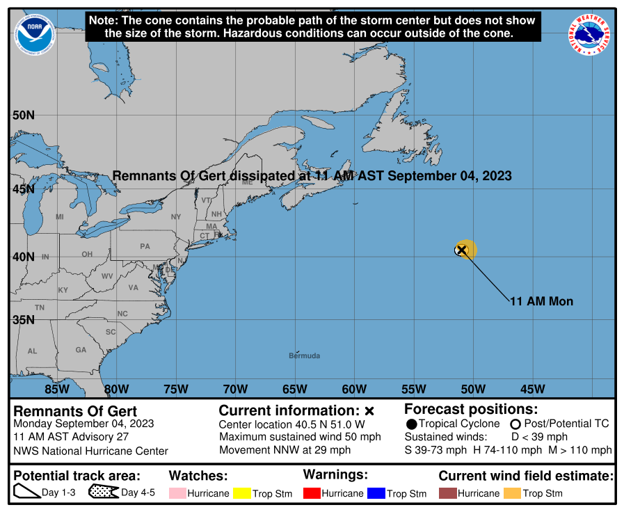
000
WTNT32 KNHC 041435
TCPAT2

BULLETIN
Remnants Of Gert Advisory Number  27
NWS National Hurricane Center Miami FL       AL062023
1100 AM AST Mon Sep 04 2023

...GERT DISSIPATES...
...THIS IS THE FINAL NHC ADVISORY ON GERT...


SUMMARY OF 1100 AM AST...1500 UTC...INFORMATION
-----------------------------------------------
LOCATION...40.5N 51.0W
ABOUT 950 MI...1530 KM NE OF BERMUDA
MAXIMUM SUSTAINED WINDS...50 MPH...85 KM/H
PRESENT MOVEMENT...NNW OR 330 DEGREES AT 29 MPH...46 KM/H
MINIMUM CENTRAL PRESSURE...1001 MB...29.56 INCHES


WATCHES AND WARNINGS
--------------------
There are no coastal watches or warnings in effect.


DISCUSSION AND OUTLOOK
----------------------
At 1100 AM AST (1500 UTC), the remnants of Gert were located near
latitude 40.5 North, longitude 51.0 West. The remnants are moving
quickly toward the north-northwest near 29 mph (46 km/h). Gert has
dissipated. Its remnants will continue to rotate around the
circulation of Post-Tropical Cyclone Idalia today.

Maximum sustained winds associated with the remnants of Gert are 50
mph (85 km/h) with higher gusts. Higher winds associated with
Post-Tropical Cyclone Idalia are occuring in the area.

Tropical-storm-force winds extend outward up to 70 miles (110 km)
from the remnants of Gert, mainly to the east and northeast.

The estimated minimum central pressure is 1001 mb (29.56 inches).


HAZARDS AFFECTING LAND
----------------------
None


NEXT ADVISORY
-------------
This is the last public advisory issued by the National Hurricane
Center on this system. Additional information on this system can be
found in High Seas Forecasts issued by the National Weather Service,
under AWIPS header NFDHSFAT1, WMO header FZNT01 KWBC, and online at
ocean.weather.gov/shtml/NFDHSFAT1.php

$$
Forecaster D. Zelinsky
Public Advisory not available for this storm.
Remnants Of GERT Forecast Discussion
000
WTNT42 KNHC 041436
TCDAT2

Remnants Of Gert Discussion Number  27
NWS National Hurricane Center Miami FL       AL062023
1100 AM AST Mon Sep 04 2023

Visible satellite imagery indicates that Gert has dissipated. It is
also no longer producing organized deep convection. Therefore, this
is the final NHC advisory on Gert.

SAR data around 0930 UTC indicated that the remnants of Gert were
still producing winds near 45 kt, and that is the basis for the max
wind analysis. The remnants of Gert will continue to move quickly
around the circulation of Post-Tropical Cyclone Idalia today. Gert
will likely be fully absorbed by Idalia by tomorrow, so there does
not appear to be any potential for another regeneration of Gert.


FORECAST POSITIONS AND MAX WINDS

INIT  04/1500Z 40.5N  51.0W   45 KT  50 MPH...REMNANTS OF GERT
 12H  05/0000Z...DISSIPATED

$$
Forecaster D. Zelinsky
GERT storm path from NHC
| Time | Speed | Location | Status |
|---|---|---|---|
| 45 knots | 40.5, -51.0 | translation missing: en.REMNANTS OF GERT | |
| 0 knots | translation missing: en.DISSIPATED |
site by Hayley Croft
- Tell your friends about Cyclocane
- make a donation - totally optional but completely appreciated
Make a monthly donation or a one-time donation to help support ongoing costs with Cyclocane.
Play solitaire and track all of the cyclocane storms at the same time at Hurricane Solitaire.