Cyclocane
( cyclocane is a CYCLOne and hurriCANE tracker by hayley )


Hayley here - Do you like lofi music whatever music Hayley put on and terrifyingly loud computer voices? Then stop by the 24/7 ish severe weather live stream!
* stats delayed and were probably not accurate to begin with
English Español Deutsch Français 日本語
This is the final warning / advisory for this storm as it has weakened below warning levels and/or the storm system is no longer a tropical cyclone.
CHANTAL Current Status
Current Wind Speed 30 knots / 35 MPH
Max Predicted Wind Speed 30 knots / 35 MPH at

Current Watches/Warnings / Radar / Satellite
current US watches/warnings

live tornado/thunderstorm tracker - tornadohq
future radar imagery - my future radar

future radar imagery

(above image is an example of the Western North Atlantic page - see Atlantic future radar page for a full set of images)
If a tropical storm or hurricane is threatening land, you can check my future radar for an idea of what radar might look like as the storm approaches.
CHANTAL Land Hazards
NWS Local Hurricane Statements
- No warnings
- RAINFALL - Tropical Depression Chantal will continue to produce heavy rainfall across portions of central North Carolina into Monday. Storm total rainfall of 2 to 4 inches, with local amounts up to 6 inches, is expected. An elevated risk for flash flooding will continue.
- TORNADOES - An isolated tornado or two is possible today over parts of eastern North Carolina.
- SURF - Life-threatening surf and rip current conditions are expected to continue at beaches along the U.S. east coast from northeastern Florida to the Mid-Atlantic states during the next day or so.
CHANTAL Tracker
CHANTAL Satellite Loop
CHANTAL Alternate Tracking Map
CHANTAL Spaghetti Models
Spaghetti models for CHANTAL can be found here:
CHANTAL spaghetti models page »
CHANTAL Watches and Warnings
Tropical Depression CHANTAL Tropical Cyclone Update
Tropical Depression CHANTAL Public Advisory
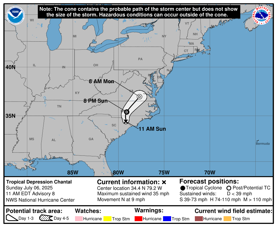
000
WTNT33 KNHC 061436
TCPAT3

BULLETIN
Tropical Depression Chantal Advisory Number   8
NWS National Hurricane Center Miami FL       AL032025
1100 AM EDT Sun Jul 06 2025

...CHANTAL MOVING INTO EASTERN NORTH CAROLINA...
...FLASH FLOOD THREAT CONTINUES AS RAINBANDS MOVE ACROSS CENTRAL AND
EASTERN NORTH CAROLINA...


SUMMARY OF 1100 AM EDT...1500 UTC...INFORMATION
-----------------------------------------------
LOCATION...34.4N 79.2W
ABOUT 20 MI...30 KM SW OF LUMBERTON NORTH CAROLINA
ABOUT 80 MI...130 KM W OF WILMINGTON NORTH CAROLINA
MAXIMUM SUSTAINED WINDS...35 MPH...55 KM/H
PRESENT MOVEMENT...N OR 360 DEGREES AT 9 MPH...15 KM/H
MINIMUM CENTRAL PRESSURE...1007 MB...29.74 INCHES


WATCHES AND WARNINGS
--------------------
CHANGES WITH THIS ADVISORY:

All Tropical Storm Warnings have been discontinued.

SUMMARY OF WATCHES AND WARNINGS IN EFFECT:

There are no coastal watches or warnings in effect.


DISCUSSION AND OUTLOOK
----------------------
At 1100 AM EDT (1500 UTC), the center of Tropical Depression Chantal
was located near latitude 34.4 North, longitude 79.2 West. The
depression is moving toward the north near 9 mph (15 km/h) and this
motion is expected to continue today. A turn toward the northeast
is expected this evening and that motion should continue into
Monday. On the forecast track, the center of Chantal is expected
to move over eastern North Carolina through tonight.

Maximum sustained winds have decreased to near 35 mph (55 km/h)
with higher gusts. Additional weakening is expected during the next
24 hours, and the system is expected to degenerate into a trough of
low pressure on Monday.

The estimated minimum central pressure is 1007 mb (29.74 inches).


HAZARDS AFFECTING LAND
----------------------
Key messages for Tropical Storm Chantal can be found in the
Tropical Cyclone Discussion under AWIPS header MIATCDAT3 and WMO
header WTNT43 KNHC.

RAINFALL: Tropical Depression Chantal will continue to produce heavy
rainfall across portions of central North Carolina into Monday.
Storm total rainfall of 2 to 4 inches, with local amounts up to 6
inches, is expected. An elevated risk for flash flooding will
continue.

For a complete depiction of forecast rainfall and flash flooding
associated with Tropical Depression Chantal, please see the National
Weather Service Storm Total Rainfall Graphic, available at
hurricanes.gov/graphics_at3.shtml?rainqpf

TORNADOES: An isolated tornado or two is possible today over parts
of eastern North Carolina.

SURF: Life-threatening surf and rip current conditions are expected
to continue at beaches along the U.S. east coast from northeastern
Florida to the Mid-Atlantic states during the next day or so.

A depiction of rip current risk for the United States can be found
at: hurricanes.gov/graphics_at3.shtml?ripCurrents


NEXT ADVISORY
-------------
This is the last public advisory issued by the National Hurricane
Center on Chantal. Future information on this system can be found in
Public Advisories issued by the Weather Prediction Center beginning
at 500 PM EDT, under AWIPS header TCPAT3, WMO header WTNT33 KWNH,
and on the web at www.hurricanes.gov.

$$
Forecaster Brown
Public Advisory not available for this storm.
Tropical Depression CHANTAL Forecast Discussion
000
WTNT43 KNHC 061436
TCDAT3

Tropical Depression Chantal Discussion Number   8
NWS National Hurricane Center Miami FL       AL032025
1100 AM EDT Sun Jul 06 2025

The center of Chantal has been moving inland over northeastern South
Carolina this morning and is currently near the North and South
Carolina border.  Surface observations indicate that the winds have
decreased, and the system is now being classified as a 30-kt
tropical depression.  The cyclone should continue to weaken today as
it moves farther inland.  The global models show the circulation
opening up into a trough of low pressure on Monday, with the remnant
moisture moving northeastward along the eastern seaboard of the U.S.
through early Tuesday.

Chantal is moving northward or 360/8 kt.  A turn toward the
northeast is anticipated later today or this evening as the cyclone
moves around the western side of a mid-level ridge located off the
U.S. East Coast. The latest track prediction is similar to the
previous advisory and is near the middle of the guidance envelope.

The primary threat from Chantal will be heavy rainfall that is
likely across portions of eastern and central North Carolina into
Monday.

This is the last advisory issued by the National Hurricane Center
on Chantal. Future advisories on this system will be issued by
the Weather Prediction Center beginning at 500 PM EDT (2100 UTC).
Those advisories can be found on the web at www.hurricanes.gov.


Key Messages:

1.Flash flood concerns continue today across portions of central
North Carolina into Monday. Isolated to scattered flash flooding
could occur within more urbanized areas.

2. Life-threatening surf and rip currents conditions are expected
to continue at beaches along the U.S. east coast from northeastern
Florida to the Mid-Atlantic states during the next day or so. Beach
goers should heed the advice of lifeguards and local officials.


FORECAST POSITIONS AND MAX WINDS

INIT  06/1500Z 34.4N  79.2W   30 KT  35 MPH...INLAND
 12H  07/0000Z 35.4N  79.1W   25 KT  30 MPH...INLAND
 24H  07/1200Z 37.0N  77.7W   25 KT  30 MPH...POST-TROP/INLAND
 36H  08/0000Z...DISSIPATED

$$
Forecaster Brown
CHANTAL storm path from NHC
| Time | Speed | Location | Status |
|---|---|---|---|
| 30 knots | 34.4, -79.2 | INLAND | |
| 25 knots | 35.4, -79.1 | INLAND | |
| 25 knots | 37.0, -77.7 | translation missing: en.POST-TROP/INLAND | |
| 0 knots | DISSIPATED |
site by Hayley Croft
Hi, I'm Hayley. Did you know that I run this site out of my own pocket? So if you'd like to help support this site:
- Tell your friends about Cyclocane
- Buy something through this Amazon Cyclocane link
- make a donation - totally optional but completely appreciated
Make a monthly donation or a one-time donation to help support ongoing costs with Cyclocane.
Play solitaire and track all of the cyclocane storms at the same time at Hurricane Solitaire.