Cyclocane
( cyclocane is a CYCLOne and hurriCANE tracker by hayley )


English Español Deutsch Français 日本語
This storm is unnamed. If the information appears to be out of date, its name may have changed, so visit the main page for the latest information.
TWO-E Current Status
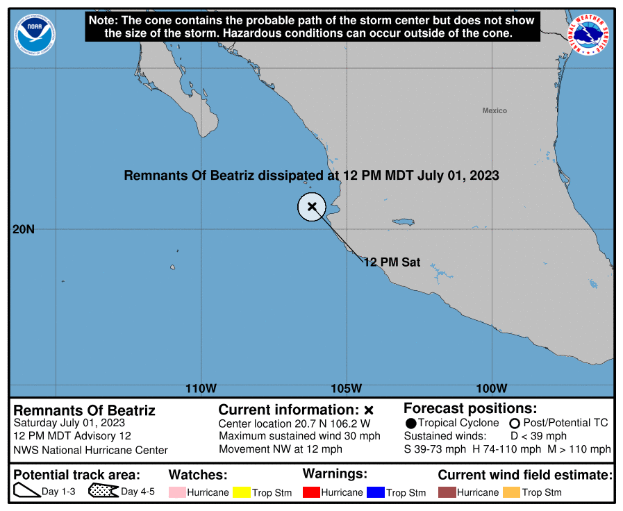
...DEPRESSION MOVING WEST-NORTHWESTWARD PARALLEL TO THE COAST OF SOUTHERN MEXICO... ...HEAVY RAINS SPREADING ONSHORE THE COASTS OF OAXACA AND GUERRERO...
Current Wind Speed 30 knots / 35 MPH
Max Predicted Wind Speed 65 knots / 75 MPH at

TWO-E Land Hazards
- WIND - Hurricane conditions are possible within the hurricane watch area Friday and Saturday. Tropical storm conditions are expected in the tropical storm warning area beginning later today and continuing through Friday evening.
- RAINFALL - Through Saturday, storm total rainfall of 3 to 5 inches, with maximum amounts of 7 inches, is expected across southern Mexico from Oaxaca west to Jalisco. This rainfall could lead to localized flash flooding.
- SURF - Swells generated by the depression are forecast to build and spread northward along the southwestern coast of Mexico during the next couple of days. These swells are likely to cause life-threatening surf and rip current conditions. Please consult products from your local weather office.
TWO-E Tracker
TWO-E Satellite Loop

TWO-E Alternate Tracking Map
TWO-E Spaghetti Models
Spaghetti models for TWO-E can be found here:
TWO-E Watches and Warnings
Tropical Depression TWO-E Tropical Cyclone Update
Tropical Depression TWO-E Public Advisory
000
WTPZ32 KNHC 291747
TCPEP2

BULLETIN
Tropical Depression Two-E Intermediate Advisory Number 3A
NWS National Hurricane Center Miami FL       EP022023
100 PM CDT Thu Jun 29 2023

...DEPRESSION MOVING WEST-NORTHWESTWARD PARALLEL TO THE COAST OF
SOUTHERN MEXICO...
...HEAVY RAINS SPREADING ONSHORE THE COASTS OF OAXACA AND
GUERRERO...


SUMMARY OF 100 PM CDT...1800 UTC...INFORMATION
----------------------------------------------
LOCATION...14.8N 99.2W
ABOUT 110 MI...180 KM SSW OF PUNTA MALDONADO MEXICO
ABOUT 150 MI...245 KM SSE OF ACAPULCO MEXICO
MAXIMUM SUSTAINED WINDS...35 MPH...55 KM/H
PRESENT MOVEMENT...WNW OR 300 DEGREES AT 13 MPH...20 KM/H
MINIMUM CENTRAL PRESSURE...1005 MB...29.68 INCHES


WATCHES AND WARNINGS
--------------------
CHANGES WITH THIS ADVISORY:

None.

SUMMARY OF WATCHES AND WARNINGS IN EFFECT:

A Hurricane Watch is in effect for...
* Lazaro Cardenas to Cabo Corrientes Mexico

A Tropical Storm Warning is in effect for...
* Punta Maldonado to Manzanillo Mexico

A Hurricane Watch means that hurricane conditions are possible
within the watch area.  A watch is typically issued 48 hours
before the anticipated first occurrence of tropical-storm-force
winds, conditions that make outside preparations difficult or
dangerous.

A Tropical Storm Warning means that tropical storm conditions are
expected somewhere within the warning area within 36 hours.

Interests along the west-central coast of Mexico and in the southern
portion of the Baja California peninsula should monitor the progress
of this system.  Additional warnings and watches may be required
later today or on Friday.

For storm information specific to your area, please monitor
products issued by your national meteorological service.


DISCUSSION AND OUTLOOK
----------------------
At 100 PM CDT (1800 UTC), the center of Tropical Depression Two-E
was located near latitude 14.8 North, longitude 99.2 West.  The
depression is moving toward the west-northwest near 13 mph.  A
west-northwestward to northwestward motion at a similar forward
speed is expected through early Saturday, followed by a decrease in
forward speed later on Saturday and Sunday.  On the forecast track,
the center of the system is expected to move parallel to and very
close to the southwestern coast of Mexico through Saturday.

Maximum sustained winds are near 35 mph (55 km/h) with higher
gusts. Strengthening is forecast, and the depression is expected to
become a tropical storm later today.  The system could become a
hurricane by Friday evening.

The estimated minimum central pressure is 1005 mb (29.68 inches).


HAZARDS AFFECTING LAND
----------------------
Key messages for Tropical Depression Two-E can be found in the
Tropical Cyclone Discussion under AWIPS header MIATCDEP2 and WMO
header WTPZ42 KNHC and on the web at
hurricanes.gov/text/miatcdep2.shtml

WIND: Hurricane conditions are possible within the hurricane watch
area Friday and Saturday.  Tropical storm conditions are expected in
the tropical storm warning area beginning later today and continuing
through Friday evening.

RAINFALL: Through Saturday, storm total rainfall of 3 to 5 inches,
with maximum amounts of 7 inches, is expected across southern Mexico
from Oaxaca west to Jalisco.  This rainfall could lead to localized
flash flooding.

SURF: Swells generated by the depression are forecast to build and
spread northward along the southwestern coast of Mexico during the
next couple of days.  These swells are likely to cause
life-threatening surf and rip current conditions.  Please consult
products from your local weather office.


NEXT ADVISORY
-------------
Next complete advisory at 400 PM CDT.

$$
Forecaster Berg
Public Advisory not available for this storm.
Tropical Depression TWO-E Forecast Discussion
000
WTPZ42 KNHC 291445
TCDEP2

Tropical Depression Two-E Discussion Number   3
NWS National Hurricane Center Miami FL       EP022023
1000 AM CDT Thu Jun 29 2023

The depression is producing a large area of deep convection off the
southern coast of Mexico, however microwave imagery indicates that
the banding features are still in the process of taking shape.
Dvorak intensity estimates are T2.5/35 kt from TAFB and T1.5/25 kt
from SAB, therefore the initial intensity remains 30 kt for this
advisory.

There is still a lot of uncertainty in the location of the
depression's center, and the estimated motion (west-northwestward,
or 300/11 kt) is primarily based on extrapolation from the previous
advisory.  A west-northwestward to northwestward motion at a fairly
constant speed is expected during the next 2 days or so while the
system moves between a mid-level ridge over northern Mexico and
Hurricane Adrian to its west.  During this period, all of the track
guidance moves the system parallel to and within 100 n mi of the
southwestern coast of Mexico, with the typically reliable ECMWF and
HCCA aids, as well as the new HAFS models, leaning on the right
side of the envelope.  The NHC track forecast is closest to those
solutions and is very similar to the previous forecast, although it
has been sped up a bit to account for recent model trends.  After
48 hours, the cyclone is expected to gradually bend toward the left
and slow down as Adrian weakens and a stronger ridge develops over
the southwestern United States.  However, it is not yet clear how
sharp that bend will be, and the system could approach the southern
part of the Baja California peninsula in 3 to 4 days.

The depression appears poised to strengthen in a low-shear and
moist environment and over very warm sea surface temperatures of
30-31 degrees Celsius.  In fact, the intensity guidance has become
much more aggressive on this forecast cycle, including an increase
in the chance for rapid intensification.  Most of the guidance
shows the cyclone reaching a peak in intensity in 36-48 hours when
it's very close to the southwestern coast of Mexico, and the new
NHC intensity forecast has been increased rather significantly
to hurricane strength during that period compared to the previous
forecast.  Even this forecast could be conservative, as several of
the regional hurricane models, as well as the IVCN and HCCA
consensus aids, are 5-25 kt higher than the official forecast at 36
hours.  A combination of shear, a drier atmosphere, and cooler
waters are expected to lead to weakening after 48 hours, and the
system could be a remnant low by day 5.


KEY MESSAGES:

1. The depression is forecast to strengthen quickly and could
become a hurricane by Friday evening, bringing a risk of strong
winds to portions of the southwestern coast of Mexico during the
next couple of days.  A Hurricane Watch is now in effect for the
coasts of Michoacan, Colima, and Jalisco, and hurricane conditions
are possible in those areas late Friday through Saturday.

2. Locally heavy rainfall of 3 to 5 inches with maximum amounts of
7 inches, is expected across southern Mexico from the state of
Oaxaca westward to the state of Jalisco.  These rains could lead to
localized flash flooding.


FORECAST POSITIONS AND MAX WINDS

INIT  29/1500Z 14.6N  98.8W   30 KT  35 MPH
 12H  30/0000Z 15.4N 100.2W   40 KT  45 MPH
 24H  30/1200Z 16.5N 101.9W   55 KT  65 MPH
 36H  01/0000Z 17.9N 103.8W   65 KT  75 MPH
 48H  01/1200Z 19.3N 105.6W   65 KT  75 MPH
 60H  02/0000Z 20.5N 106.8W   60 KT  70 MPH
 72H  02/1200Z 21.4N 107.9W   55 KT  65 MPH
 96H  03/1200Z 22.1N 109.9W   40 KT  45 MPH
120H  04/1200Z 22.5N 112.1W   25 KT  30 MPH...POST-TROP/REMNT LOW

$$
Forecaster Berg
TWO-E storm path from NHC
| Time | Speed | Location | Status |
|---|---|---|---|
| 30 knots | 14.8, -99.2 | ||
| 40 knots | 15.4, -100.2 | ||
| 55 knots | 16.5, -101.9 | ||
| 65 knots | 17.9, -103.8 | ||
| 65 knots | 19.3, -105.6 | ||
| 60 knots | 20.5, -106.8 | ||
| 55 knots | 21.4, -107.9 | ||
| 40 knots | 22.1, -109.9 | ||
| 25 knots | 22.5, -112.1 | POST-TROPICAL CYCLONE |
site by Hayley Croft
Want to help support this site?
- Tell your friends about Cyclocane
- make a donation - totally optional but completely appreciated
Make a monthly donation or a one-time donation to help support ongoing costs with Cyclocane.
Play solitaire and track all of the cyclocane storms at the same time at Hurricane Solitaire.