Cyclocane
( cyclocane is a CYCLOne and hurriCANE tracker by hayley )


English Español Deutsch Français 日本語
This is the final warning / advisory for this storm as it has weakened below warning levels and/or the storm system is no longer a tropical cyclone.
This storm is unnamed. If the information appears to be out of date, its name may have changed, so visit the main page for the latest information.
TWENTY-ONE Current Status
Current Wind Speed 20 knots / 25 MPH
Max Predicted Wind Speed 20 knots / 25 MPH at

Current Watches/Warnings / Radar / Satellite
current US watches/warnings

live tornado/thunderstorm tracker - tornadohq
future radar imagery - my future radar

future radar imagery

(above image is an example of the Western North Atlantic page - see Atlantic future radar page for a full set of images)
If a tropical storm or hurricane is threatening land, you can check my future radar for an idea of what radar might look like as the storm approaches.
TWENTY-ONE Land Hazards
NWS Local Hurricane Statements
- No warnings
- RAINFALL - The remnants of the tropical depression are expected to produce additional rainfall totals of 4 to 8 inches with maximum amounts of 12 inches across Nicaragua and 2 to 4 inches with maximum amounts of 6 inches across southern and eastern Honduras. These rains are likely to produce flash and urban flooding, along with mudslides in areas of higher terrain.
TWENTY-ONE Tracker
TWENTY-ONE Satellite Loop
TWENTY-ONE Alternate Tracking Map
TWENTY-ONE Spaghetti Models
Spaghetti models for TWENTY-ONE can be found here:
TWENTY-ONE spaghetti models page »
TWENTY-ONE Watches and Warnings
Remnants Of TWENTY-ONE Tropical Cyclone Update
Remnants Of TWENTY-ONE Public Advisory
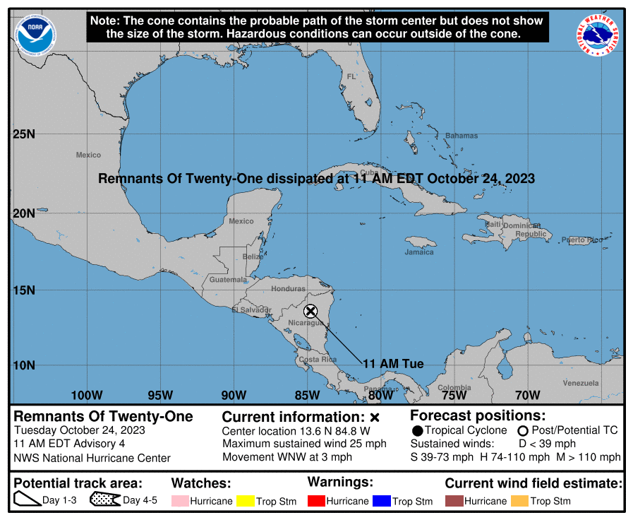
000
WTNT31 KNHC 241456
TCPAT1

BULLETIN
Remnants Of Twenty-One Advisory Number   4
NWS National Hurricane Center Miami FL       AL212023
1100 AM EDT Tue Oct 24 2023

...TROPICAL DEPRESSION DISSIPATES INLAND...
...THIS IS THE LAST ADVISORY...


SUMMARY OF 1100 AM EDT...1500 UTC...INFORMATION
-----------------------------------------------
LOCATION...13.6N 84.8W
ABOUT 130 MI...210 KM NNW OF BLUEFIELDS NICARAGUA
MAXIMUM SUSTAINED WINDS...25 MPH...35 KM/H
PRESENT MOVEMENT...WNW OR 290 DEGREES AT 3 MPH...6 KM/H
MINIMUM CENTRAL PRESSURE...1007 MB...29.74 INCHES


WATCHES AND WARNINGS
--------------------
There are no coastal watches or warnings in effect.


DISCUSSION AND OUTLOOK
----------------------
At 1100 AM EDT (1500 UTC), the remnants of Tropical Depression
Twenty-One were located near latitude 13.6 North, longitude 84.8
West. The remnants are moving toward the west-northwest near 3 mph
(6 km/h) and gradual turn toward the west is expected soon.

Maximum sustained winds are near 25 mph (35 km/h) with higher gusts.

The estimated minimum central pressure is 1007 mb (29.74 inches).


HAZARDS AFFECTING LAND
----------------------
Key messages for the remnants of Tropical Depression Twenty-One can
be found in the Tropical Cyclone Discussion under AWIPS header
MIATCDAT1 and WMO header WTNT41 KNHC.

RAINFALL:  The remnants of the tropical depression are expected to
produce additional rainfall totals of 4 to 8 inches with maximum
amounts of 12 inches across Nicaragua and 2 to 4 inches with maximum
amounts of 6 inches across southern and eastern Honduras. These
rains are likely to produce flash and urban flooding, along with
mudslides in areas of higher terrain.


NEXT ADVISORY
-------------
This is the last public advisory issued by the National Hurricane
Center on this system.

$$
Forecaster Bucci
Public Advisory not available for this storm.
Remnants Of TWENTY-ONE Forecast Discussion
000
WTNT41 KNHC 241457
TCDAT1

Remnants Of Twenty-One Discussion Number   4
NWS National Hurricane Center Miami FL       AL212023
1100 AM EDT Tue Oct 24 2023

Satellite images show that the convection associated with Tropical
Depression Twenty-One has weakened, and there are no signs of a
well-defined surface center.  Thus the system has dissipated over
Nicaragua and the initial wind speed is set to 20 kt.  The remnants
of the system are forecast to continue west-northwestward to
westward and cross over to the eastern Pacific by Wednesday.  Heavy
rainfall with flash and urban flooding remain the primary impacts
even as the system dissipates.

This is the last advisory from the National Hurricane Center on
this system.


KEY MESSAGES:

1. Heavy rains from the remnants of the depression will continue to
impact portions of Nicaragua through Tuesday night with heavy
rainfall spreading into Honduras during the day on Tuesday. This
rainfall is likely to produce flash and urban flooding, along with
possible mudslides in areas of higher terrain.


FORECAST POSITIONS AND MAX WINDS

INIT  24/1500Z 13.6N  84.8W   20 KT  25 MPH...REMNANTS OF
 12H  25/0000Z...DISSIPATED

$$
Forecaster Bucci
TWENTY-ONE storm path from NHC
| Time | Speed | Location | Status |
|---|---|---|---|
| 20 knots | 13.6, -84.8 | REMNANTS OF | |
| 0 knots | translation missing: en.DISSIPATED |
site by Hayley Croft
- Tell your friends about Cyclocane
- make a donation - totally optional but completely appreciated
Make a monthly donation or a one-time donation to help support ongoing costs with Cyclocane.
Play solitaire and track all of the cyclocane storms at the same time at Hurricane Solitaire.