Cyclocane
( cyclocane is a CYCLOne and hurriCANE tracker by hayley )


English Español Deutsch Français 日本語
This is the final warning / advisory for this storm as it has weakened below warning levels and/or the storm system is no longer a tropical cyclone.
TAMMY Current Status
Current Wind Speed 35 knots / 40 MPH
Max Predicted Wind Speed 35 knots / 40 MPH at

Current Watches/Warnings / Radar / Satellite
current US watches/warnings

live tornado/thunderstorm tracker - tornadohq
future radar imagery - my future radar

future radar imagery

(above image is an example of the Western North Atlantic page - see Atlantic future radar page for a full set of images)
If a tropical storm or hurricane is threatening land, you can check my future radar for an idea of what radar might look like as the storm approaches.
TAMMY Land Hazards
NWS Local Hurricane Statements
- No warnings
TAMMY Tracker
TAMMY Satellite Loop
TAMMY Alternate Tracking Map
TAMMY Spaghetti Models
Spaghetti models for TAMMY can be found here:
TAMMY Watches and Warnings
Post-Tropical Cyclone TAMMY Tropical Cyclone Update
Post-Tropical Cyclone TAMMY Public Advisory
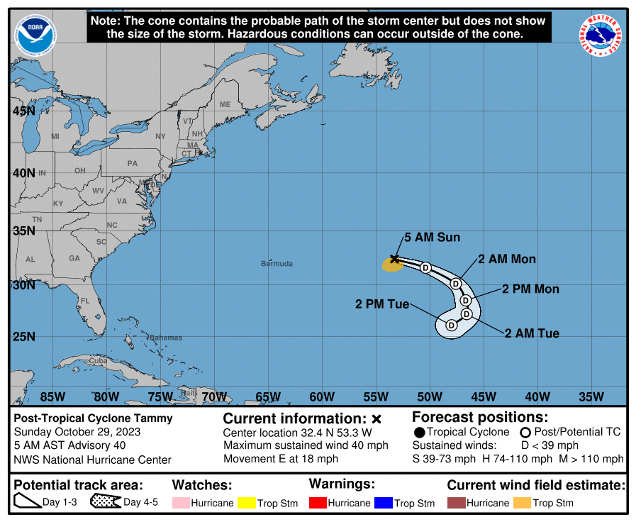
000
WTNT35 KNHC 290835
TCPAT5

BULLETIN
Post-Tropical Cyclone Tammy Advisory Number  40
NWS National Hurricane Center Miami FL       AL202023
500 AM AST Sun Oct 29 2023

...TAMMY NOW A POST-TROPICAL CYCLONE...
...THIS IS THE LAST NHC ADVISORY...


SUMMARY OF 500 AM AST...0900 UTC...INFORMATION
----------------------------------------------
LOCATION...32.4N 53.3W
ABOUT 670 MI...1080 KM E OF BERMUDA
MAXIMUM SUSTAINED WINDS...40 MPH...65 KM/H
PRESENT MOVEMENT...E OR 100 DEGREES AT 18 MPH...30 KM/H
MINIMUM CENTRAL PRESSURE...1002 MB...29.59 INCHES


WATCHES AND WARNINGS
--------------------
There are no coastal watches or warnings in effect.


DISCUSSION AND OUTLOOK
----------------------
At 500 AM AST (0900 UTC), the center of Post-Tropical Cyclone Tammy
was located near latitude 32.4 North, longitude 53.3 West. The
post-tropical cyclone is moving toward the east near 18 mph (30
km/h).  A turn to the south is expected tonight, followed by a
motion to the southwest on Monday and Tuesday.

Maximum sustained winds are near 40 mph (65 km/h) with higher gusts.
Gradual weakening is expected during the next couple of days.

Tropical-storm-force winds extend outward up to 90 miles (150 km)
south of the center.

The estimated minimum central pressure is 1002 mb (29.59 inches).


HAZARDS AFFECTING LAND
----------------------
None.


NEXT ADVISORY
-------------
This is the last public advisory issued by the National Hurricane
Center on Tammy.  Additional information on this system can be found
in High Seas Forecasts issued by the National Weather Service,
under AWIPS header NFDHSFAT1, WMO header FZNT01 KWBC, and online at
ocean.weather.gov/shtml/NFDHSFAT1.php

$$
Forecaster Cangialosi
Public Advisory not available for this storm.
Post-Tropical Cyclone TAMMY Forecast Discussion
000
WTNT45 KNHC 290836
TCDAT5

Post-Tropical Cyclone Tammy Discussion Number  40
NWS National Hurricane Center Miami FL       AL202023
500 AM AST Sun Oct 29 2023

During the past 18 to 24 hours, Tammy has only been maintaining a
small and disorganized patch of deep convection well to the
northeast of the fully exposed center.  Accordingly, the Dvorak
classifications have been decreasing, and the latest estimate from
TAFB is a T1.0/2.0.  Satellite images also show that the low-level
center has become elongated and is losing definition.  Based on
these characteristics, Tammy no longer qualifies as a tropical
cyclone, and this is the last advisory on this system.  The
initial intensity is held at 35 kt.

Tammy is moving eastward at 16 kt in the mid-latitude westerlies. A
fairly sharp turn to the south is expected to occur tonight followed
by a motion to the southwest on Monday and Tuesday as the
post-tropical cyclone moves around the east side of a building
subtropical ridge.  Tammy is expected to slowly weaken due to
continued strong vertical wind shear and dry air entrainment, and it
will likely dissipate in a few days.

Additional and future information on this system can be found in
High Seas Forecasts issued by the National Weather Service, under
AWIPS header NFDHSFAT1, WMO header FZNT01 KWBC, and online at
ocean.weather.gov/shtml/NFDHSFAT1.php


FORECAST POSITIONS AND MAX WINDS

INIT  29/0900Z 32.4N  53.3W   35 KT  40 MPH...POST-TROPICAL
 12H  29/1800Z 31.6N  50.4W   30 KT  35 MPH...POST-TROP/REMNT LOW
 24H  30/0600Z 30.1N  47.6W   30 KT  35 MPH...POST-TROP/REMNT LOW
 36H  30/1800Z 28.5N  46.7W   25 KT  30 MPH...POST-TROP/REMNT LOW
 48H  31/0600Z 27.2N  46.6W   20 KT  25 MPH...POST-TROP/REMNT LOW
 60H  31/1800Z 26.1N  48.0W   20 KT  25 MPH...POST-TROP/REMNT LOW
 72H  01/0600Z...DISSIPATED

$$
Forecaster Cangialosi
TAMMY storm path from NHC
| Time | Speed | Location | Status |
|---|---|---|---|
| 35 knots | 32.4, -53.3 | translation missing: en.POST-TROPICAL | |
| 30 knots | 31.6, -50.4 | POST-TROPICAL CYCLONE | |
| 30 knots | 30.1, -47.6 | POST-TROPICAL CYCLONE | |
| 25 knots | 28.5, -46.7 | POST-TROPICAL CYCLONE | |
| 20 knots | 27.2, -46.6 | POST-TROPICAL CYCLONE | |
| 20 knots | 26.1, -48.0 | POST-TROPICAL CYCLONE | |
| 0 knots | translation missing: en.DISSIPATED |
site by Hayley Croft
- Tell your friends about Cyclocane
- make a donation - totally optional but completely appreciated
Make a monthly donation or a one-time donation to help support ongoing costs with Cyclocane.
Play solitaire and track all of the cyclocane storms at the same time at Hurricane Solitaire.