Cyclocane
( cyclocane is a CYCLOne and hurriCANE tracker by hayley )


English Español Deutsch Français 日本語
This is the final warning / advisory for this storm as it has weakened below warning levels and/or the storm system is no longer a tropical cyclone.
RAMON Current Status
...RAMON BECOMES A REMNANT LOW... ...THIS IS THE LAST ADVISORY...
Current Wind Speed 30 knots / 35 MPH
Max Predicted Wind Speed 30 knots / 35 MPH at

RAMON Land Hazards
RAMON Tracker
RAMON Satellite Loop

RAMON Alternate Tracking Map
RAMON Spaghetti Models
Spaghetti models for RAMON can be found here:
RAMON Watches and Warnings
Post-Tropical Cyclone RAMON Tropical Cyclone Update
Post-Tropical Cyclone RAMON Public Advisory
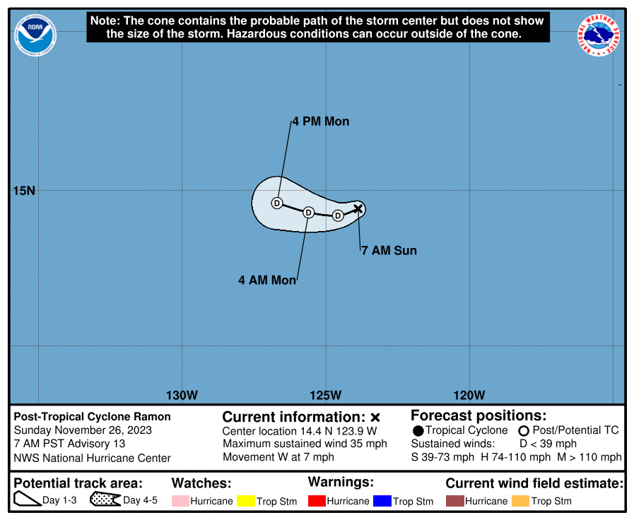
000
WTPZ35 KNHC 261441
TCPEP5

BULLETIN
Post-Tropical Cyclone Ramon Advisory Number  13
NWS National Hurricane Center Miami FL       EP202023
700 AM PST Sun Nov 26 2023

...RAMON BECOMES A REMNANT LOW...
...THIS IS THE LAST ADVISORY...


SUMMARY OF 700 AM PST...1500 UTC...INFORMATION
----------------------------------------------
LOCATION...14.4N 123.9W
ABOUT 1085 MI...1750 KM WSW OF THE SOUTHERN TIP OF BAJA CALIFORNIA
MAXIMUM SUSTAINED WINDS...35 MPH...55 KM/H
PRESENT MOVEMENT...W OR 260 DEGREES AT 7 MPH...11 KM/H
MINIMUM CENTRAL PRESSURE...1006 MB...29.71 INCHES


WATCHES AND WARNINGS
--------------------
There are no coastal watches or warnings in effect.


DISCUSSION AND OUTLOOK
----------------------
At 700 AM PST (1500 UTC), the center of Post-Tropical Cyclone Ramon
was located near latitude 14.4 North, longitude 123.9 West.  The
post-tropical cyclone is moving toward the west near 7 mph (11 km/h)
and this general motion is expected to continue for the next
couple of days.

Maximum sustained winds have decreased to near 35 mph (55 km/h)
with higher gusts.  Continued gradual weakening is forecast, and
the remnant low is likely to dissipate by late Monday.

The estimated minimum central pressure is 1006 mb (29.71 inches).


HAZARDS AFFECTING LAND
----------------------
None.


NEXT ADVISORY
-------------
This is the last public advisory issued by the National Hurricane
Center on this system.  For additional information on the remnant
low please see High Seas Forecasts issued by the National Weather
Service, under AWIPS header NFDHSFEPI, WMO header FZPN02 KWBC, and
on the web at
ocean.weather.gov/shtml/NFDHSFEPI.php


$$
Forecaster Pasch
Public Advisory not available for this storm.
Post-Tropical Cyclone RAMON Forecast Discussion
000
WTPZ45 KNHC 261441
TCDEP5

Post-Tropical Cyclone Ramon Discussion Number  13
NWS National Hurricane Center Miami FL       EP202023
700 AM PST Sun Nov 26 2023

Ramon is producing some isolated deep convection to the north and
northeast of the center, but the system has lacked significant
thunderstorm activity for the last 12 hours or so.  Therefore Ramon
is being designated as a remnant low at this time, and this is the
last advisory.  The current intensity estimate is set at 30 kt
based on the assumption of a gradual spin down overnight.  this is
also in agreement with satellite estimates from SAB and TAFB

Although the cyclone could still produce a few sporadic bursts of
showers and thunderstorms for the next day or so, strong westerly
shear on the order of 40 to 50 kt and dry low- to mid-tropospheric
air should preclude the redevelopment of significant, organized deep
convection.  This is also consistent with simulated satellite
imagery from the global models that show little or no deep
convection associated with the system for the next few days.  The
cyclone should continue to weaken, and dissipate in 48 hours or so.

A mainly westward track is likely to continue into early next week
while the cyclone moves within the near-surface tradewind flow.

For additional information on Ramon's remnant low please see High
Seas Forecasts issued by the National Weather Service, under AWIPS
header NFDHSFEPI, WMO header FZPN02 KWBC, and on the web at
ocean.weather.gov/shtml/NFDHSFEPI.php


FORECAST POSITIONS AND MAX WINDS

INIT  26/1500Z 14.4N 123.9W   30 KT  35 MPH...POST-TROP/REMNT LOW
 12H  27/0000Z 14.2N 124.6W   25 KT  30 MPH...POST-TROP/REMNT LOW
 24H  27/1200Z 14.3N 125.6W   20 KT  25 MPH...POST-TROP/REMNT LOW
 36H  28/0000Z 14.6N 126.7W   20 KT  25 MPH...POST-TROP/REMNT LOW
 48H  28/1200Z...DISSIPATED

$$
Forecaster Pasch
RAMON storm path from NHC
| Time | Speed | Location | Status |
|---|---|---|---|
| 30 knots | 14.4, -123.9 | POST-TROPICAL CYCLONE | |
| 25 knots | 14.2, -124.6 | POST-TROPICAL CYCLONE | |
| 20 knots | 14.3, -125.6 | POST-TROPICAL CYCLONE | |
| 20 knots | 14.6, -126.7 | POST-TROPICAL CYCLONE | |
| 0 knots | translation missing: en.DISSIPATED |
site by Hayley Croft
Want to help support this site?
- Tell your friends about Cyclocane
- make a donation - totally optional but completely appreciated
Make a monthly donation or a one-time donation to help support ongoing costs with Cyclocane.
Play solitaire and track all of the cyclocane storms at the same time at Hurricane Solitaire.