Cyclocane
( cyclocane is a CYCLOne and hurriCANE tracker by hayley )


English Español Deutsch Français 日本語
This is the final warning / advisory for this storm as it has weakened below warning levels and/or the storm system is no longer a tropical cyclone.
This storm is unnamed. If the information appears to be out of date, its name may have changed, so visit the main page for the latest information.
PTC-TWENTY-TWO Current Status
Current Wind Speed 30 knots / 35 MPH
Max Predicted Wind Speed 30 knots / 35 MPH at

Current Watches/Warnings / Radar / Satellite
current US watches/warnings

live tornado/thunderstorm tracker - tornadohq
future radar imagery - my future radar

future radar imagery

(above image is an example of the Western North Atlantic page - see Atlantic future radar page for a full set of images)
If a tropical storm or hurricane is threatening land, you can check my future radar for an idea of what radar might look like as the storm approaches.
PTC-TWENTY-TWO Land Hazards
NWS Local Hurricane Statements
- No warnings
- RAINFALL - This disturbance is expected to produce additional total rainfall of 4 to 8 inches with maximum amounts of 14 inches across portions of southeastern Cuba and southern Hispaniola through Sunday. These rains are likely to produce flash flooding, along with mudslides in areas of higher terrain.
- SURF - Swells generated by the disturbance are expected to affect portions of Jamaica, Haiti, and southeastern Cuba through Saturday. These swells are likely to cause life-threatening surf and rip current conditions. Please consult products from your local weather office.
PTC-TWENTY-TWO Tracker
PTC-TWENTY-TWO Satellite Loop
PTC-TWENTY-TWO Alternate Tracking Map
PTC-TWENTY-TWO Spaghetti Models
Spaghetti models for PTC-TWENTY-TWO can be found here:
PTC-TWENTY-TWO spaghetti models page »
PTC-TWENTY-TWO Watches and Warnings
Potential Tropical Cyclone PTC-TWENTY-TWO Tropical Cyclone Update
Potential Tropical Cyclone PTC-TWENTY-TWO Public Advisory
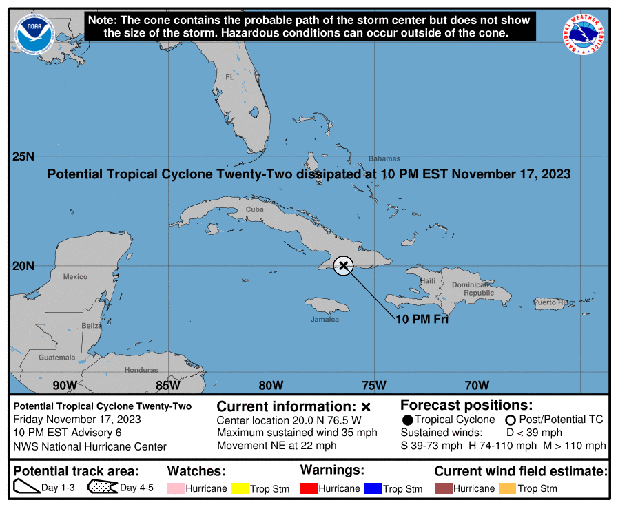
000
WTNT32 KNHC 180238
TCPAT2

BULLETIN
Potential Tropical Cyclone Twenty-Two Advisory Number   6
NWS National Hurricane Center Miami FL       AL222023
1000 PM EST Fri Nov 17 2023

...HEAVY RAINS LIKELY TO PRODUCE LIFE-THREATENING FLASH FLOODING AND
MUDSLIDES ACROSS SOUTHEASTERN CUBA AND HISPANIOLA THIS WEEKEND...
...THIS IS THE FINAL NHC ADVISORY AS ALL WATCHES HAVE BEEN
DISCONTINUED AND TROPICAL CYCLONE FORMATION IS NOT EXPECTED...


SUMMARY OF 1000 PM EST...0300 UTC...INFORMATION
-----------------------------------------------
LOCATION...20.0N 76.5W
ABOUT 140 MI...220 KM NE OF MONTEGO BAY JAMAICA
ABOUT 85 MI...135 KM W OF GUANTANAMO CUBA
MAXIMUM SUSTAINED WINDS...35 MPH...55 KM/H
PRESENT MOVEMENT...NE OR 45 DEGREES AT 22 MPH...35 KM/H
MINIMUM CENTRAL PRESSURE...1006 MB...29.71 INCHES


WATCHES AND WARNINGS
--------------------
CHANGES WITH THIS ADVISORY:

The Tropical Storm Watch for Haiti has been discontinued.

SUMMARY OF WATCHES AND WARNINGS IN EFFECT:

There are no coastal watches or warnings in effect.

For storm information specific to your area, please monitor products
issued by your national meteorological service.


DISCUSSION AND OUTLOOK
----------------------
At 1000 PM EST (0300 UTC), the disturbance was centered near
latitude 20.0 North, longitude 76.5 West. The system is moving
toward the northeast near 22 mph (35 km/h), and a faster
northeastward motion is expected overnight. On the forecast track,
the disturbance is expected to move across southeastern Cuba during
the next few hours.

Maximum sustained winds are near 35 mph (55 km/h) with higher gusts.
The disturbance appears unlikely to become a tropical cyclone before
it merges with a frontal system later this weekend.
* Formation chance through 48 hours...low...10 percent.
* Formation chance through 7 days...low...10 percent.

The estimated minimum central pressure is 1006 mb (29.71 inches).


HAZARDS AFFECTING LAND
----------------------
Key messages for Potential Tropical Cyclone Twenty-Two can be found
in the Tropical Cyclone Discussion under AWIPS header MIATCDAT2 and
WMO header WTNT42 KNHC, and on the web at
hurricanes.gov/text/MIATCDAT2.shtml

RAINFALL:  This disturbance is expected to produce additional total
rainfall of 4 to 8 inches with maximum amounts of 14 inches across
portions of southeastern Cuba and southern Hispaniola through
Sunday. These rains are likely to produce flash flooding, along with
mudslides in areas of higher terrain.

The system is expected to produce an additional 2 to 4 inches of
rainfall across Jamaica, the southeastern Bahamas, as well as the
Turks and Caicos Islands. This rainfall may lead to flash flooding
in urban areas.

SURF:  Swells generated by the disturbance are expected to affect
portions of Jamaica, Haiti, and southeastern Cuba through Saturday.
These swells are likely to cause life-threatening surf and rip
current conditions. Please consult products from your local weather
office.


NEXT ADVISORY
-------------
This is the last public advisory issued by the National Hurricane
Center on this system. Additional information on this system can be
found in High Seas Forecasts issued by the National Weather Service,
under AWIPS header NFDHSFAT1, WMO header FZNT01 KWBC, and online at
ocean.weather.gov/shtml/NFDHSFAT1.php

$$
Forecaster Reinhart
Public Advisory not available for this storm.
Potential Tropical Cyclone PTC-TWENTY-TWO Forecast Discussion
000
WTNT42 KNHC 180239
TCDAT2

Potential Tropical Cyclone Twenty-Two Discussion Number   6
NWS National Hurricane Center Miami FL       AL222023
1000 PM EST Fri Nov 17 2023

The broad disturbance has failed to become better organized today.
The associated convection remains displaced well to the east of the
surface trough axis by strong southwesterly shear. The earlier
aircraft reconnaissance data showed the disturbance was only
producing peak winds of 25-30 kt. Given its lack of a well-defined
surface center, poor convective organization, and the continued
hostile environmental conditions it faces, this system is no longer
expected to become a tropical cyclone. Additionally, the risk of
sustained tropical-storm-force winds on land has greatly diminished,
and all tropical storm watches have been discontinued. Therefore,
this will be the final NHC advisory on this system.

The remnants of this disturbance are expected to accelerate
northeastward ahead of a shortwave trough and merge with a frontal
system over the southwestern Atlantic Ocean later this weekend.
Although tropical cyclone formation is not expected, there is high
confidence that heavy rainfall and flooding will remain a serious
threat across southeastern Cuba and Hispaniola through Sunday.
Additional rainfall amounts of 4 to 8 inches, with maximum amounts
of 14 inches, are expected across portions of these areas, which is
likely to produce life-threatening flash flooding and mudslides.

For storm information specific to your area, please monitor products
issued by your national meteorological service. Additional
information on this system can be found in High Seas Forecasts
issued by the National Weather Service, under AWIPS header
NFDHSFAT1, WMO header FZNT01 KWBC, and online at
ocean.weather.gov/shtml/NFDHSFAT1.php


KEY MESSAGES:

1. Heavy rains from this disturbance will impact portions of
southeastern Cuba and southern Hispaniola through Sunday. This
rainfall is likely to produce flash flooding, along with mudslides
in areas of higher terrain. Lighter amounts across Jamaica, the
southeastern Bahamas, and the Turks and Caicos Islands may lead to
flash flooding in urban areas.


FORECAST POSITIONS AND MAX WINDS

INIT  18/0300Z 20.0N  76.5W   30 KT  35 MPH...INLAND
 12H  18/1200Z...DISSIPATED

$$
Forecaster Reinhart
PTC-TWENTY-TWO storm path from NHC
| Time | Speed | Location | Status |
|---|---|---|---|
| 30 knots | 20.0, -76.5 | translation missing: en.INLAND | |
| 0 knots | translation missing: en.DISSIPATED |
site by Hayley Croft
- Tell your friends about Cyclocane
- make a donation - totally optional but completely appreciated
Make a monthly donation or a one-time donation to help support ongoing costs with Cyclocane.
Play solitaire and track all of the cyclocane storms at the same time at Hurricane Solitaire.