Cyclocane
( cyclocane is a CYCLOne and hurriCANE tracker by hayley )


English Español Deutsch Français 日本語
This is the final warning / advisory for this storm as it has weakened below warning levels and/or the storm system is no longer a tropical cyclone.
PILAR Current Status
...PILAR DEGENERATES INTO A REMNANT LOW... ...THIS IS THE LAST ADVISORY...
Current Wind Speed 30 knots / 35 MPH
Max Predicted Wind Speed 30 knots / 35 MPH at

PILAR Land Hazards
PILAR Tracker
PILAR Satellite Loop

PILAR Alternate Tracking Map
PILAR Spaghetti Models
Spaghetti models for PILAR can be found here:
PILAR Watches and Warnings
Post-Tropical Cyclone PILAR Tropical Cyclone Update
Post-Tropical Cyclone PILAR Public Advisory
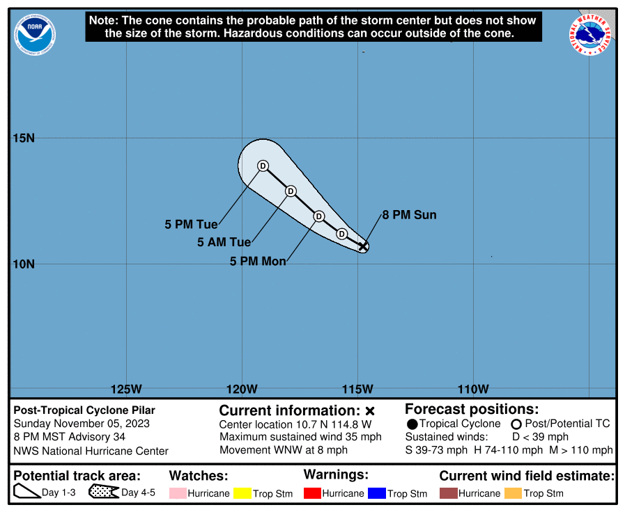
229
WTPZ34 KNHC 060241
TCPEP4

BULLETIN
Post-Tropical Cyclone Pilar Advisory Number  34
NWS National Hurricane Center Miami FL       EP192023
800 PM MST Sun Nov 05 2023

...PILAR DEGENERATES INTO A REMNANT LOW...
...THIS IS THE LAST ADVISORY...


SUMMARY OF 800 PM MST...0300 UTC...INFORMATION
----------------------------------------------
LOCATION...10.7N 114.8W
ABOUT 900 MI...1450 KM SSW OF THE SOUTHERN TIP OF BAJA CALIFORNIA
MAXIMUM SUSTAINED WINDS...35 MPH...55 KM/H
PRESENT MOVEMENT...WNW OR 285 DEGREES AT 8 MPH...13 KM/H
MINIMUM CENTRAL PRESSURE...1006 MB...29.71 INCHES


WATCHES AND WARNINGS
--------------------
There are no coastal watches or warnings in effect.


DISCUSSION AND OUTLOOK
----------------------
At 800 PM MST (0300 UTC), the center of Post-Tropical Cyclone Pilar
was located near latitude 10.7 North, longitude 114.8 West. The
post-tropical cyclone is moving toward the west-northwest near 8 mph
(13 km/h).  A west-northwest to northwest motion is expected during
the next couple of days.

Maximum sustained winds have decreased to near 35 mph (55 km/h)
with higher gusts.  Additional weakening is forecast, and the
remnant low is forecast to dissipate in a couple of days.

The estimated minimum central pressure is 1006 mb (29.71 inches).


HAZARDS AFFECTING LAND
----------------------
None.


NEXT ADVISORY
-------------
This is the last public advisory issued by the National Hurricane
Center on Pilar. Additional information on the remnant low can be
found in High Seas Forecasts issued by the National Weather
Service, under AWIPS header NFDHSFEPI, WMO header FZPN02 KWBC, and
on the web at ocean.weather.gov/shtml/NFDHSFEPI.php

$$
Forecaster Brown
Public Advisory not available for this storm.
Post-Tropical Cyclone PILAR Forecast Discussion
000
WTPZ44 KNHC 060242
TCDEP4

Post-Tropical Cyclone Pilar Discussion Number  34
NWS National Hurricane Center Miami FL       EP192023
800 PM MST Sun Nov 05 2023

After the low- and mid-level centers of Pilar decoupled this
morning, the system has failed to produce any deep convection near
the center.  Although the system is still located over warm SSTs,
dry mid-level air and strong mid-level shear is likely to prevent
organized deep convection from returning.  Therefore, Pilar has
become a post-tropical remnant low.  The initial wind speed has been
lowered to 30 kt, based on a blend of the available satellite
estimates, but this could be generous.  The system could still
produce a few bursts of deep convection during the next day or so,
but it should continue to gradually spin down.  The global model
guidance indicates that the circulation will degenerate into a
trough of low pressure within 2-3 days, if not sooner.

They cyclone is moving west-northwestward at about 7 kt.  A
west-northwestward to northwestward motion is expected during the
next day or two as the low- to mid-level ridge to the north of the
system weakens.  Since the system has become vertically shallow, the
NHC track is along the left or south side of the guidance envelop
between the shallow Trajectory and Beta model (TABS), and the GFS
and UKMET ensemble means.

This is the last NHC advisory on Pilar. Additional information
on the remnant low can be found in High Seas Forecasts issued by the
National Weather Service, under AWIPS header NFDHSFEPI, WMO header
FZPN02 KWBC, and on the web at ocean.weather.gov/shtml/NFDHSFEPI.php


FORECAST POSITIONS AND MAX WINDS

INIT  06/0300Z 10.7N 114.8W   30 KT  35 MPH...POST-TROPICAL
 12H  06/1200Z 11.2N 115.7W   25 KT  30 MPH...POST-TROP/REMNT LOW
 24H  07/0000Z 11.9N 116.7W   25 KT  30 MPH...POST-TROP/REMNT LOW
 36H  07/1200Z 12.9N 117.9W   20 KT  25 MPH...POST-TROP/REMNT LOW
 48H  08/0000Z 13.9N 119.1W   20 KT  25 MPH...POST-TROP/REMNT LOW
 60H  08/1200Z...DISSIPATED

$$
Forecaster Brown
PILAR storm path from NHC
| Time | Speed | Location | Status |
|---|---|---|---|
| 30 knots | 10.7, -114.8 | translation missing: en.POST-TROPICAL | |
| 25 knots | 11.2, -115.7 | POST-TROPICAL CYCLONE | |
| 25 knots | 11.9, -116.7 | POST-TROPICAL CYCLONE | |
| 20 knots | 12.9, -117.9 | POST-TROPICAL CYCLONE | |
| 20 knots | 13.9, -119.1 | POST-TROPICAL CYCLONE | |
| 0 knots | translation missing: en.DISSIPATED |
site by Hayley Croft
Want to help support this site?
- Tell your friends about Cyclocane
- make a donation - totally optional but completely appreciated
Make a monthly donation or a one-time donation to help support ongoing costs with Cyclocane.
Play solitaire and track all of the cyclocane storms at the same time at Hurricane Solitaire.