Cyclocane
( cyclocane is a CYCLOne and hurriCANE tracker by hayley )


English Español Deutsch Français 日本語
This is the final warning / advisory for this storm as it has weakened below warning levels and/or the storm system is no longer a tropical cyclone.
OTIS Current Status
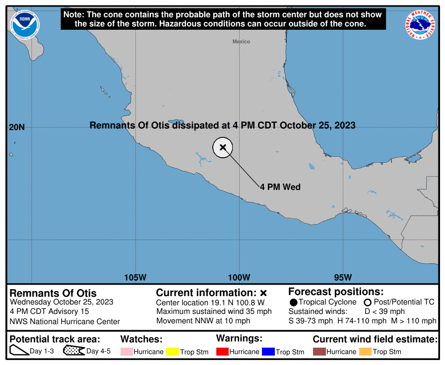
...OTIS DISSIPATES INLAND OVER SOUTHERN MEXICO... ...THIS IS THE LAST ADVISORY...
Current Wind Speed 30 knots / 35 MPH
Max Predicted Wind Speed 30 knots / 35 MPH at

OTIS Land Hazards
- RAINFALL - The remnants of Otis are expected to produce additional rainfall totals of 2-4 inches (locally as high as 6) through Thursday across Guerrero, Mexico, and Morelos. A rainfall total of 9 inches was already observed at Cigua de Benitez in the state of Guerrero. This rainfall will produce flash and urban flooding, along with mudslides in areas of higher terrain.
OTIS Tracker
OTIS Satellite Loop

OTIS Alternate Tracking Map
OTIS Spaghetti Models
Spaghetti models for OTIS can be found here:
OTIS Watches and Warnings
Remnants Of OTIS Tropical Cyclone Update
Remnants Of OTIS Public Advisory
000
WTPZ33 KNHC 252031
TCPEP3

BULLETIN
Remnants Of Otis Advisory Number  15
NWS National Hurricane Center Miami FL       EP182023
400 PM CDT Wed Oct 25 2023

...OTIS DISSIPATES INLAND OVER SOUTHERN MEXICO...
...THIS IS THE LAST ADVISORY...


SUMMARY OF 400 PM CDT...2100 UTC...INFORMATION
----------------------------------------------
LOCATION...19.1N 100.8W
ABOUT 165 MI...260 KM NNW OF ACAPULCO MEXICO
MAXIMUM SUSTAINED WINDS...35 MPH...55 KM/H
PRESENT MOVEMENT...NNW OR 340 DEGREES AT 10 MPH...17 KM/H
MINIMUM CENTRAL PRESSURE...985 MB...29.09 INCHES


WATCHES AND WARNINGS
--------------------
CHANGES WITH THIS ADVISORY:

The government of Mexico has discontinued the Tropical Storm
Warning from Punta Maldonado to Acapulco.

SUMMARY OF WATCHES AND WARNINGS IN EFFECT:

There are no coastal watches or warnings in effect.


DISCUSSION AND OUTLOOK
----------------------
At 400 PM CDT (2100 UTC), the remnants of Otis were located near
latitude 19.1 North, longitude 100.8 West.  The remnants are moving
toward the north-northwest near 10 mph (17 km/h) and this general
motion is expected to continue tonight.

Maximum sustained winds are near 35 mph (55 km/h) with higher gusts.

The estimated minimum central pressure is 985 mb (29.09 inches).


HAZARDS AFFECTING LAND
----------------------
RAINFALL:  The remnants of Otis are expected to produce additional
rainfall totals of 2-4 inches (locally as high as 6) through
Thursday across Guerrero, Mexico, and Morelos.  A rainfall total of
9 inches was already observed at Cigua de Benitez in the state of
Guerrero.  This rainfall will produce flash and urban flooding,
along with mudslides in areas of higher terrain.


NEXT ADVISORY
-------------
This is the last public advisory issued by the National Hurricane
Center on this system.

$$
Forecaster Pasch
Public Advisory not available for this storm.
Remnants Of OTIS Forecast Discussion
000
WTPZ43 KNHC 252031
TCDEP3

Remnants Of Otis Discussion Number  15
NWS National Hurricane Center Miami FL       EP182023
400 PM CDT Wed Oct 25 2023

High-resolution visible satellite imagery and synoptic observations
indicate that the surface circulation of Otis has dissipated
over the mountains of southern Mexico.  Therefore, this is the last
advisory on this system.

The remnants of Otis will continue to produce locally heavy rains
and flooding through Thursday.


Key Messages:

1. Heavy rains from Otis will continue to impact areas of
southwestern and south-central Mexico through Thursday. This
rainfall will produce flash and urban flooding, along with mudslides
in areas of higher terrain.


FORECAST POSITIONS AND MAX WINDS

INIT  25/2100Z 19.1N 100.8W   30 KT  35 MPH...REMNANTS OF OTIS
 12H  26/0600Z...DISSIPATED

$$
Forecaster Pasch
OTIS storm path from NHC
| Time | Speed | Location | Status |
|---|---|---|---|
| 30 knots | 19.1, -100.8 | translation missing: en.REMNANTS OF OTIS | |
| 0 knots | translation missing: en.DISSIPATED |
site by Hayley Croft
Want to help support this site?
- Tell your friends about Cyclocane
- make a donation - totally optional but completely appreciated
Make a monthly donation or a one-time donation to help support ongoing costs with Cyclocane.
Play solitaire and track all of the cyclocane storms at the same time at Hurricane Solitaire.