Cyclocane
( cyclocane is a CYCLOne and hurriCANE tracker by hayley )


English Español Deutsch Français 日本語
This is the final warning / advisory for this storm as it has weakened below warning levels and/or the storm system is no longer a tropical cyclone.
NORMA Current Status
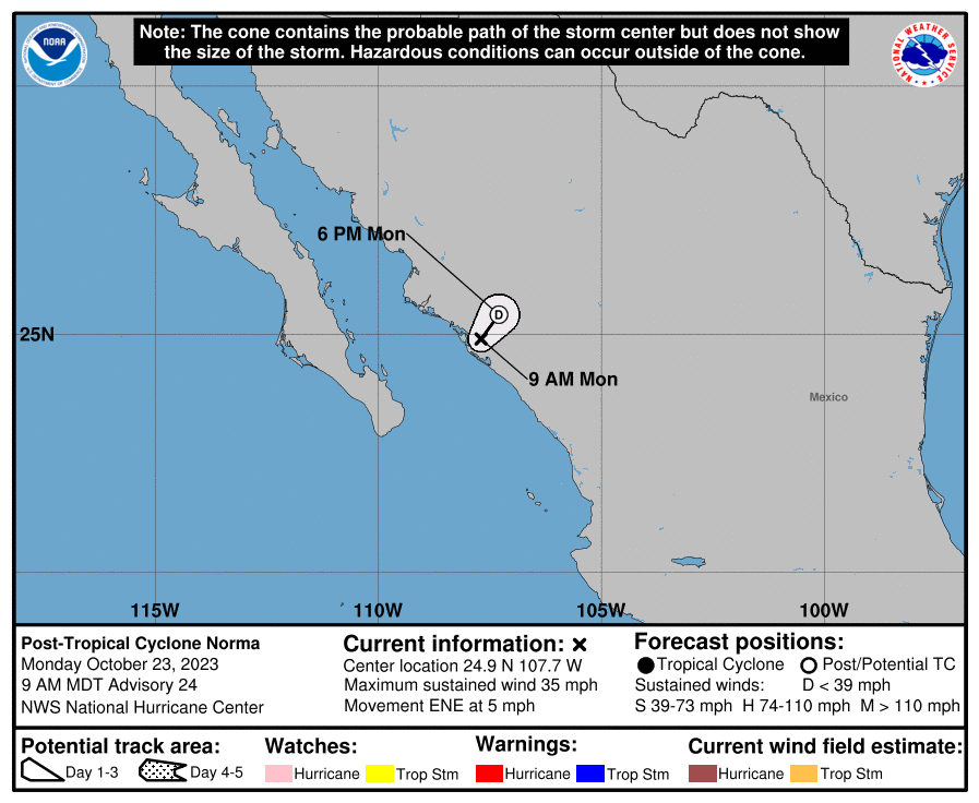
...NORMA BECOMES A REMNANT LOW... ...THIS IS THE LAST NHC ADVISORY...
Current Wind Speed 30 knots / 35 MPH
Max Predicted Wind Speed 30 knots / 35 MPH at

NORMA Land Hazards
NORMA Tracker
NORMA Satellite Loop

NORMA Alternate Tracking Map
NORMA Spaghetti Models
Spaghetti models for NORMA can be found here:
NORMA Watches and Warnings
Post-Tropical Cyclone NORMA Tropical Cyclone Update
Post-Tropical Cyclone NORMA Public Advisory
000
WTPZ32 KNHC 231440
TCPEP2

BULLETIN
Post-Tropical Cyclone Norma Advisory Number  24
NWS National Hurricane Center Miami FL       EP172023
900 AM MDT Mon Oct 23 2023

...NORMA BECOMES A REMNANT LOW...
...THIS IS THE LAST NHC ADVISORY...


SUMMARY OF 900 AM MDT...1500 UTC...INFORMATION
----------------------------------------------
LOCATION...24.9N 107.7W
ABOUT 15 MI...25 KM WNW OF CULIACAN MEXICO
MAXIMUM SUSTAINED WINDS...35 MPH...55 KM/H
PRESENT MOVEMENT...ENE OR 70 DEGREES AT 5 MPH...7 KM/H
MINIMUM CENTRAL PRESSURE...1000 MB...29.53 INCHES


WATCHES AND WARNINGS
--------------------
There are no coastal watches or warnings in effect.


DISCUSSION AND OUTLOOK
----------------------
At 900 AM MDT (1500 UTC), the center of Post-Tropical Cyclone Norma
was located near latitude 24.9 North, longitude 107.7 West. The
post-tropical cyclone is moving toward the east-northeast near 5 mph
(7 km/h) and this general motion is expected through tonight.

Maximum sustained winds are near 35 mph (55 km/h) with higher gusts.
Norma is expected to dissipate later today or tonight.

The estimated minimum central pressure is 1000 mb (29.53 inches).


HAZARDS AFFECTING LAND
----------------------
None.


NEXT ADVISORY
-------------
This is the last public advisory issued by the National Hurricane
Center on Norma.

$$
Forecaster Cangialosi
Public Advisory not available for this storm.
Post-Tropical Cyclone NORMA Forecast Discussion
000
WTPZ42 KNHC 231441
TCDEP2

Post-Tropical Cyclone Norma Discussion Number  24
NWS National Hurricane Center Miami FL       EP172023
900 AM MDT Mon Oct 23 2023

Norma made landfall as a tropical depression around 1030 UTC fairly
close to Eldorado in the state of Sinaloa.  The system has lacked
organized deep convection for more than 12 hours, and therefore, no
longer qualifies as a tropical cyclone.  The remnant low is
estimated to have maximum winds around 30 kt, which are likely
confined to the waters just off the coast of Sinaloa.

The remnant low is expected to weaken and dissipate over the rugged
terrain of Mexico later today or tonight.  The remnant moisture
could still result in areas of heavy rain in portions of northern
Mexico throughout the day.

This is the last NHC advisory on Norma.


FORECAST POSITIONS AND MAX WINDS

INIT  23/1500Z 24.9N 107.7W   30 KT  35 MPH...POST-TROPICAL
 12H  24/0000Z 25.4N 107.3W   20 KT  25 MPH...POST-TROP/INLAND
 24H  24/1200Z...DISSIPATED

$$
Forecaster Cangialosi
NORMA storm path from NHC
| Time | Speed | Location | Status |
|---|---|---|---|
| 30 knots | 24.9, -107.7 | translation missing: en.POST-TROPICAL | |
| 20 knots | 25.4, -107.3 | translation missing: en.POST-TROP/INLAND | |
| 0 knots | translation missing: en.DISSIPATED |
site by Hayley Croft
Want to help support this site?
- Tell your friends about Cyclocane
- make a donation - totally optional but completely appreciated
Make a monthly donation or a one-time donation to help support ongoing costs with Cyclocane.
Play solitaire and track all of the cyclocane storms at the same time at Hurricane Solitaire.