Cyclocane
( cyclocane is a CYCLOne and hurriCANE tracker by hayley )


English Español Deutsch Français 日本語
This is the final warning / advisory for this storm as it has weakened below warning levels and/or the storm system is no longer a tropical cyclone.
MARGOT Current Status
Current Wind Speed 35 knots / 40 MPH
Max Predicted Wind Speed 35 knots / 40 MPH at

Current Watches/Warnings / Radar / Satellite
current US watches/warnings

live tornado/thunderstorm tracker - tornadohq
future radar imagery - my future radar

future radar imagery

(above image is an example of the Western North Atlantic page - see Atlantic future radar page for a full set of images)
If a tropical storm or hurricane is threatening land, you can check my future radar for an idea of what radar might look like as the storm approaches.
MARGOT Land Hazards
NWS Local Hurricane Statements
- No warnings
- SURF - Swells generated by Margot will continue to affect the Azores for the next several days. These swells are likely to cause life-threatening surf and rip current conditions. Please consult products from your local weather office.
MARGOT Tracker
MARGOT Satellite Loop
MARGOT Alternate Tracking Map
MARGOT Spaghetti Models
Spaghetti models for MARGOT can be found here:
MARGOT spaghetti models page »
MARGOT Watches and Warnings
Post-Tropical Cyclone MARGOT Tropical Cyclone Update
Post-Tropical Cyclone MARGOT Public Advisory
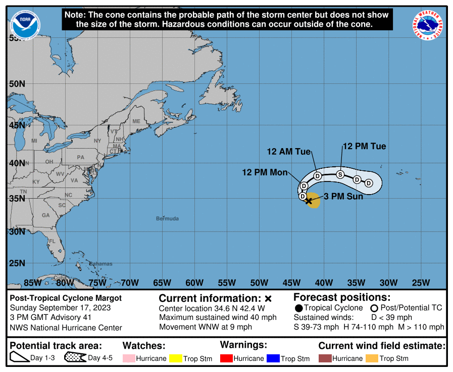
000
WTNT34 KNHC 171436
TCPAT4

BULLETIN
Post-Tropical Cyclone Margot Advisory Number  41
NWS National Hurricane Center Miami FL       AL142023
300 PM GMT Sun Sep 17 2023

...MARGOT NO LONGER A TROPICAL CYCLONE...
...THIS IS THE LAST NHC ADVISORY...


SUMMARY OF 300 PM GMT...1500 UTC...INFORMATION
----------------------------------------------
LOCATION...34.6N 42.4W
ABOUT 885 MI...1430 KM W OF THE AZORES
MAXIMUM SUSTAINED WINDS...40 MPH...65 KM/H
PRESENT MOVEMENT...WNW OR 300 DEGREES AT 9 MPH...15 KM/H
MINIMUM CENTRAL PRESSURE...1001 MB...29.56 INCHES


WATCHES AND WARNINGS
--------------------
There are no coastal watches or warnings in effect.


DISCUSSION AND OUTLOOK
----------------------
At 300 PM GMT (1500 UTC), the center of Post-Tropical Cyclone Margot
was located near latitude 34.6 North, longitude 42.4 West. The
post-tropical cyclone is moving toward the west-northwest near 9 mph
(15 km/h). A clockwise turn resulting in a motion toward the east
is expected over the next couple of days.

Maximum sustained winds are near 40 mph (65 km/h) with higher gusts.
Small fluctuations in intensity are expected during the next few
days.

Tropical-storm-force winds extend outward up to 105 miles (165 km)
from the center.

The estimated minimum central pressure is 1001 mb (29.56 inches).


HAZARDS AFFECTING LAND
----------------------
SURF: Swells generated by Margot will continue to affect the Azores
for the next several days. These swells are likely to cause
life-threatening surf and rip current conditions. Please consult
products from your local weather office.


NEXT ADVISORY
-------------
This is the last public advisory issued by the National Hurricane
Center on this system. Additional information on this system can be
found in High Seas Forecasts issued by the National Weather Service,
under AWIPS header NFDHSFAT1, WMO header FZNT01 KWBC, and online at
ocean.weather.gov/shtml/NFDHSFAT1.php

$$
Forecaster D. Zelinsky
Public Advisory not available for this storm.
Post-Tropical Cyclone MARGOT Forecast Discussion
785
WTNT44 KNHC 171437
TCDAT4

Post-Tropical Cyclone Margot Discussion Number  41
NWS National Hurricane Center Miami FL       AL142023
300 PM GMT Sun Sep 17 2023

Margot has lacked organized deep convection since around 00 UTC and
is no longer a tropical cyclone. Therefore, this is the last NHC
advisory.

The latest Dvorak current intensity estimate from TAFB is the basis
for the 35 kt initial intensity. Regeneration in the short term is
not expected due to high wind shear and dry surrounding air. With no
deep convection, the cyclone's winds should gradually decrease over
the next day or so. The post-tropical cyclone is forecast to turn
slowly northward today and tonight, and then turn eastward by
Tuesday in the wake of Post-Tropical Lee, which will be passing well
to the north. While Margot's maximum winds could fluctuate slightly
during this time, it could also open into a trough as early as
Tuesday. After that, the cyclone or its remnants should meander west
of the Azores for a day or two until it ultimately dissipates
southeast of Nigel late this week.

Additional information on this system can be found in High Seas
Forecasts issued by the National Weather Service, under AWIPS
header NFDHSFAT1, WMO header FZNT01 KWBC, and online at
ocean.weather.gov/shtml/NFDHSFAT1.php

FORECAST POSITIONS AND MAX WINDS

INIT  17/1500Z 34.6N  42.4W   35 KT  40 MPH...POST-TROPICAL
 12H  18/0000Z 35.3N  43.3W   30 KT  35 MPH...POST-TROP/REMNT LOW
 24H  18/1200Z 36.8N  43.1W   30 KT  35 MPH...POST-TROP/REMNT LOW
 36H  19/0000Z 38.2N  41.0W   30 KT  35 MPH...POST-TROP/REMNT LOW
 48H  19/1200Z 38.4N  37.5W   35 KT  40 MPH...POST-TROPICAL
 60H  20/0000Z 37.7N  34.9W   30 KT  35 MPH...POST-TROP/REMNT LOW
 72H  20/1200Z 37.2N  33.1W   30 KT  35 MPH...POST-TROP/REMNT LOW
 96H  21/1200Z...DISSIPATED

$$
Forecaster D. Zelinsky
MARGOT storm path from NHC
| Time | Speed | Location | Status |
|---|---|---|---|
| 35 knots | 34.6, -42.4 | translation missing: en.POST-TROPICAL | |
| 30 knots | 35.3, -43.3 | POST-TROPICAL CYCLONE | |
| 30 knots | 36.8, -43.1 | POST-TROPICAL CYCLONE | |
| 30 knots | 38.2, -41.0 | POST-TROPICAL CYCLONE | |
| 35 knots | 38.4, -37.5 | translation missing: en.POST-TROPICAL | |
| 30 knots | 37.7, -34.9 | POST-TROPICAL CYCLONE | |
| 30 knots | 37.2, -33.1 | POST-TROPICAL CYCLONE | |
| 0 knots | translation missing: en.DISSIPATED |
site by Hayley Croft
- Tell your friends about Cyclocane
- make a donation - totally optional but completely appreciated
Make a monthly donation or a one-time donation to help support ongoing costs with Cyclocane.
Play solitaire and track all of the cyclocane storms at the same time at Hurricane Solitaire.