Cyclocane
( cyclocane is a CYCLOne and hurriCANE tracker by hayley )


English Español Deutsch Français 日本語
This is the final warning / advisory for this storm as it has weakened below warning levels and/or the storm system is no longer a tropical cyclone.
JOVA Current Status
...DANGEROUS SURF AND RIP CURRENT CONDITIONS CONTINUE ALONG THE COASTS OF CALIFORNIA AND MEXICO... ...THIS IS THE LAST ADVISORY AS JOVA BECOMES A REMNANT LOW...
Current Wind Speed 30 knots / 35 MPH
Max Predicted Wind Speed 30 knots / 35 MPH at

JOVA Land Hazards
- SURF - Swells generated by Jova are affecting the western coast of Mexico and are occuring along portions of the coast of California. These swells are likely to cause life-threatening surf and rip current conditions through Monday. Please consult products from your local weather office.
JOVA Tracker
JOVA Satellite Loop

JOVA Alternate Tracking Map
JOVA Spaghetti Models
Spaghetti models for JOVA can be found here:
JOVA Watches and Warnings
Post-Tropical Cyclone JOVA Tropical Cyclone Update
Post-Tropical Cyclone JOVA Public Advisory
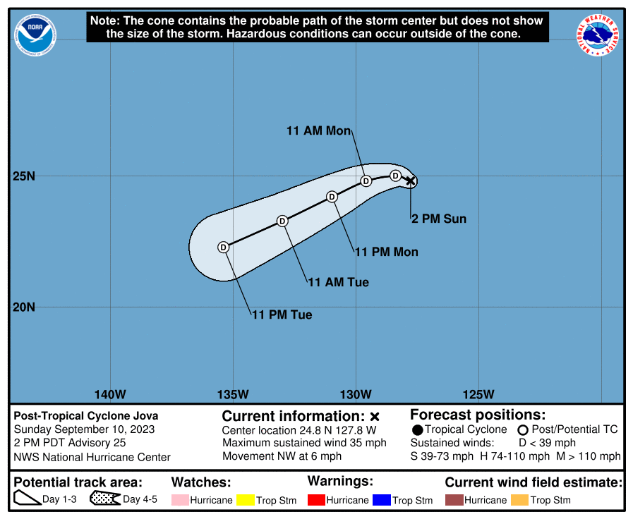
399
WTPZ31 KNHC 102035
TCPEP1

BULLETIN
Post-Tropical Cyclone Jova Advisory Number  25
NWS National Hurricane Center Miami FL       EP112023
200 PM PDT Sun Sep 10 2023

...DANGEROUS SURF AND RIP CURRENT CONDITIONS CONTINUE ALONG THE
COASTS OF CALIFORNIA AND MEXICO...
...THIS IS THE LAST ADVISORY AS JOVA BECOMES A REMNANT LOW...


SUMMARY OF 200 PM PDT...2100 UTC...INFORMATION
----------------------------------------------
LOCATION...24.8N 127.8W
ABOUT 1135 MI...1830 KM W OF THE SOUTHERN TIP OF BAJA CALIFORNIA
MAXIMUM SUSTAINED WINDS...35 MPH...55 KM/H
PRESENT MOVEMENT...NW OR 305 DEGREES AT 6 MPH...9 KM/H
MINIMUM CENTRAL PRESSURE...1005 MB...29.68 INCHES


WATCHES AND WARNINGS
--------------------
There are no coastal watches or warnings in effect.


DISCUSSION AND OUTLOOK
----------------------
At 200 PM PDT (2100 UTC), the center of Post-Tropical Cyclone Jova
was located near latitude 24.8 North, longitude 127.8 West. The
post-tropical cyclone is moving toward the northwest near 6 mph (9
km/h). A gradual turn toward the west and west-southwest is expected
over the next couple of days.

Maximum sustained winds have decreased to near 35 mph (55 km/h) with
higher gusts. Jova has become a remnant low and will continue to
gradually spin down.

The estimated minimum central pressure is 1005 mb (29.68 inches).


HAZARDS AFFECTING LAND
----------------------
SURF: Swells generated by Jova are affecting the western coast of
Mexico and are occuring along portions of the coast of California.
These swells are likely to cause life-threatening surf and rip
current conditions through Monday.  Please consult products
from your local weather office.


NEXT ADVISORY
-------------
This is the last public advisory issued by the National Hurricane
Center on this system.  For additional information on the remnant
low please see High Seas Forecasts issued by the National Weather
Service, under AWIPS header NFDHSFEPI, WMO header FZPN02 KWBC, and
on the web at
ocean.weather.gov/shtml/NFDHSFEPI.php

$$
Forecaster Kelly
Public Advisory not available for this storm.
Post-Tropical Cyclone JOVA Forecast Discussion
000
WTPZ41 KNHC 102036
TCDEP1

Post-Tropical Cyclone Jova Discussion Number  25
NWS National Hurricane Center Miami FL       EP112023
200 PM PDT Sun Sep 10 2023

Jova has been devoid of deep convection for roughly 12 hours or so.
The overall cloud pattern  continues to become disheveled, as the
system gradually spins down. Given that the system has not been
producing convection for some time now, it no longer meets the
definition of a tropical cyclone. Therefore, Jova has degenerated
into a post-tropical remnant low. The initial intensity is lowered
to 30 kt for this advisory, based on a recent scatterometer pass
which is in agreement with the latest subjective and objective
satellite intensity estimates.

Jova will continue to spin down for the next couple of days as
it remains a remnant low, before opening up into a trough in about
72 h. No significant changes were made to the official forecast,
which lies near the consensus intensity aids.

Jova's initial motion is estimated to be northwestward at 5 kt, A
gradual turn toward the west and west-southwest, with an increase in
forward motion is forecast. The NHC forecast lies near the middle
of the guidance envelope, near the model consensus.

This is the last advisory on this system from the National Hurricane
Center. For additional information on the remnant low please see
High Seas Forecasts issued by the National Weather Service...under
AWIPS header NFDHSFEPI and WMO header FZPN02 KWBC.

FORECAST POSITIONS AND MAX WINDS

INIT  10/2100Z 24.8N 127.8W   30 KT  35 MPH...POST-TROP/REMNT LOW
 12H  11/0600Z 25.0N 128.4W   25 KT  30 MPH...POST-TROP/REMNT LOW
 24H  11/1800Z 24.8N 129.6W   25 KT  30 MPH...POST-TROP/REMNT LOW
 36H  12/0600Z 24.2N 131.0W   25 KT  30 MPH...POST-TROP/REMNT LOW
 48H  12/1800Z 23.3N 133.0W   25 KT  30 MPH...POST-TROP/REMNT LOW
 60H  13/0600Z 22.3N 135.4W   25 KT  30 MPH...POST-TROP/REMNT LOW
 72H  13/1800Z...DISSIPATED

$$
Forecaster Kelly
JOVA storm path from NHC
| Time | Speed | Location | Status |
|---|---|---|---|
| 30 knots | 24.8, -127.8 | POST-TROPICAL CYCLONE | |
| 25 knots | 25.0, -128.4 | POST-TROPICAL CYCLONE | |
| 25 knots | 24.8, -129.6 | POST-TROPICAL CYCLONE | |
| 25 knots | 24.2, -131.0 | POST-TROPICAL CYCLONE | |
| 25 knots | 23.3, -133.0 | POST-TROPICAL CYCLONE | |
| 25 knots | 22.3, -135.4 | POST-TROPICAL CYCLONE | |
| 0 knots | translation missing: en.DISSIPATED |
site by Hayley Croft
Want to help support this site?
- Tell your friends about Cyclocane
- make a donation - totally optional but completely appreciated
Make a monthly donation or a one-time donation to help support ongoing costs with Cyclocane.
Play solitaire and track all of the cyclocane storms at the same time at Hurricane Solitaire.