Cyclocane
( cyclocane is a CYCLOne and hurriCANE tracker by hayley )


English Español Deutsch Français 日本語
This is the final warning / advisory for this storm as it has weakened below warning levels and/or the storm system is no longer a tropical cyclone.
EMILY Current Status
Current Wind Speed 30 knots / 35 MPH
Max Predicted Wind Speed 30 knots / 35 MPH at

Current Watches/Warnings / Radar / Satellite
current US watches/warnings

live tornado/thunderstorm tracker - tornadohq
future radar imagery - my future radar

future radar imagery

(above image is an example of the Western North Atlantic page - see Atlantic future radar page for a full set of images)
If a tropical storm or hurricane is threatening land, you can check my future radar for an idea of what radar might look like as the storm approaches.
EMILY Land Hazards
NWS Local Hurricane Statements
San Diego CA EP092023 ...TROPICAL STORM WARNING IS CANCELLED...Los Angeles/Oxnard CA EP092023 **ALL TROPICAL STORM WARNINGS HAVE BEEN CANCELED, BUT FLOODING RAIN THREAT REMAINS INTO MONDAY**
San Diego CA EP092023 ...TROPICAL STORM WARNING IS CANCELLED...
Los Angeles/Oxnard CA EP092023 **ALL TROPICAL STORM WARNINGS HAVE BEEN CANCELED, BUT FLOODING RAIN THREAT REMAINS INTO MONDAY**
EMILY Tracker
EMILY Satellite Loop
EMILY Alternate Tracking Map
EMILY Spaghetti Models
Spaghetti models for EMILY can be found here:
EMILY Watches and Warnings
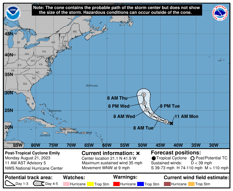
Post-Tropical Cyclone EMILY Tropical Cyclone Update
Post-Tropical Cyclone EMILY Public Advisory
000
WTNT32 KNHC 211430
TCPAT2

BULLETIN
Post-Tropical Cyclone Emily Advisory Number   5
NWS National Hurricane Center Miami FL       AL072023
1100 AM AST Mon Aug 21 2023

...EMILY IS NOW A REMNANT LOW...
...THIS IS THE LAST NHC ADVISORY ON EMILY...


SUMMARY OF 1100 AM AST...1500 UTC...INFORMATION
-----------------------------------------------
LOCATION...21.1N 41.9W
ABOUT 1225 MI...1965 KM WNW OF THE CABO VERDE ISLANDS
MAXIMUM SUSTAINED WINDS...35 MPH...55 KM/H
PRESENT MOVEMENT...WNW OR 290 DEGREES AT 9 MPH...15 KM/H
MINIMUM CENTRAL PRESSURE...1006 MB...29.71 INCHES


WATCHES AND WARNINGS
--------------------
There are no coastal watches or warnings in effect.


DISCUSSION AND OUTLOOK
----------------------
At 1100 AM AST (1500 UTC), the center of Post-Tropical Cyclone Emily
was located near latitude 21.1 North, longitude 41.9 West. The
post-tropical cyclone is moving toward the west-northwest near 9 mph
(15 km/h) and this general motion is forecast to continue today.
Emily could turn more toward the north-northwest or north by
mid-week.

Maximum sustained winds are near 35 mph (55 km/h) with higher gusts.
Slow weakening is expected during the next couple of days.

The estimated minimum central pressure is 1006 mb (29.71 inches).


HAZARDS AFFECTING LAND
----------------------
None.


NEXT ADVISORY
-------------
This is the last public advisory issued by the National Hurricane
Center on this system. Additional information on this system can be
found in High Seas Forecasts issued by the National Weather Service,
under AWIPS header NFDHSFAT1, WMO header FZNT01 KWBC, and online at
ocean.weather.gov/shtml/NFDHSFAT1.php

$$
Forecaster D. Zelinsky
Public Advisory not available for this storm.
Post-Tropical Cyclone EMILY Forecast Discussion
842
WTNT42 KNHC 211430
TCDAT2

Post-Tropical Cyclone Emily Discussion Number   5
NWS National Hurricane Center Miami FL       AL072023
1100 AM AST Mon Aug 21 2023

Emily has been devoid of deep convection for nearly 15 hours and no
longer meets the definition of a tropical cyclone. Although sea
surface temperatures are sufficiently warm to support occasional
bursts of convection, strong wind shear and a very dry environment
should prevent it from re-organizing as a tropical cyclone for at
least the next couple days. The initial intensity of 30 kt is based
on ASCAT-B data valid at 1200 UTC.

In about 3 days, the remnant low is forecast to turn northward as it
encounters a deep-layer trough over the central Atlantic. While it
turns, Emily could briefly encounter a more favorable upper-level
wind pattern, which could support the redevelopment of convection.
However, the low-level center may also become stretched and
ill-defined at the same time. Regeneration as a tropical cyclone
does not appear likely enough to explicitly forecast it at this
time. Information on the potential for regeneration will be included
in future Tropical Weather Outlooks, if necessary. Future
information on Emily can also be found in High Seas forecasts issued
by the National Hurricane Center and Ocean Prediction Center.


FORECAST POSITIONS AND MAX WINDS

INIT  21/1500Z 21.1N  41.9W   30 KT  35 MPH...POST-TROP/REMNT LOW
 12H  22/0000Z 21.6N  43.4W   30 KT  35 MPH...POST-TROP/REMNT LOW
 24H  22/1200Z 22.5N  45.5W   30 KT  35 MPH...POST-TROP/REMNT LOW
 36H  23/0000Z 23.6N  47.4W   30 KT  35 MPH...POST-TROP/REMNT LOW
 48H  23/1200Z 25.2N  48.8W   30 KT  35 MPH...POST-TROP/REMNT LOW
 60H  24/0000Z 27.1N  49.5W   30 KT  35 MPH...POST-TROP/REMNT LOW
 72H  24/1200Z 29.5N  49.7W   30 KT  35 MPH...POST-TROP/REMNT LOW
 96H  25/1200Z...DISSIPATED

$$
Forecaster D. Zelinsky
EMILY storm path from NHC
| Time | Speed | Location | Status |
|---|---|---|---|
| 30 knots | 21.1, -41.9 | POST-TROPICAL CYCLONE | |
| 30 knots | 21.6, -43.4 | POST-TROPICAL CYCLONE | |
| 30 knots | 22.5, -45.5 | POST-TROPICAL CYCLONE | |
| 30 knots | 23.6, -47.4 | POST-TROPICAL CYCLONE | |
| 30 knots | 25.2, -48.8 | POST-TROPICAL CYCLONE | |
| 30 knots | 27.1, -49.5 | POST-TROPICAL CYCLONE | |
| 30 knots | 29.5, -49.7 | POST-TROPICAL CYCLONE | |
| 0 knots | translation missing: en.DISSIPATED |
site by Hayley Croft
- Tell your friends about Cyclocane
- make a donation - totally optional but completely appreciated
Make a monthly donation or a one-time donation to help support ongoing costs with Cyclocane.
Play solitaire and track all of the cyclocane storms at the same time at Hurricane Solitaire.