Cyclocane
( cyclocane is a CYCLOne and hurriCANE tracker by hayley )


English Español Deutsch Français 日本語
This is the final warning / advisory for this storm as it has weakened below warning levels and/or the storm system is no longer a tropical cyclone.
DON Current Status
Current Wind Speed 40 knots / 45 MPH
Max Predicted Wind Speed 40 knots / 45 MPH at
Current Watches/Warnings / Radar / Satellite
current US watches/warnings

live tornado/thunderstorm tracker - tornadohq
future radar imagery - my future radar

future radar imagery

(above image is an example of the Western North Atlantic page - see Atlantic future radar page for a full set of images)
If a tropical storm or hurricane is threatening land, you can check my future radar for an idea of what radar might look like as the storm approaches.
DON Land Hazards
NWS Local Hurricane Statements
- No warnings
DON Tracker
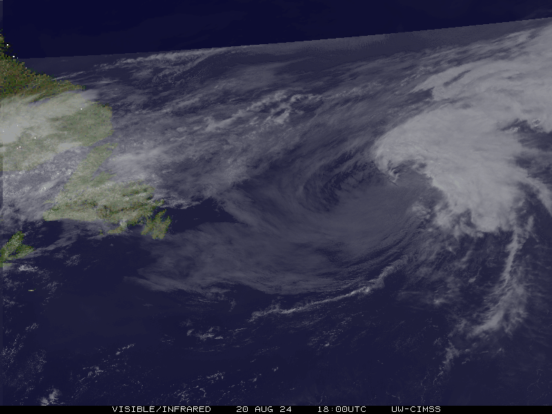
DON Satellite Loop
DON Alternate Tracking Map
DON Spaghetti Models
Spaghetti models for DON can be found here:
DON Watches and Warnings
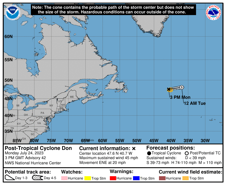
Post-Tropical Cyclone DON Tropical Cyclone Update
Post-Tropical Cyclone DON Public Advisory
000
WTNT35 KNHC 241502
TCPAT5

BULLETIN
Post-Tropical Cyclone Don Advisory Number  42
NWS National Hurricane Center Miami FL       AL052023
300 PM GMT Mon Jul 24 2023

...DON NOW A POST-TROPICAL CYCLONE...
...THIS IS THE LAST ADVISORY...


SUMMARY OF 300 PM GMT...1500 UTC...INFORMATION
----------------------------------------------
LOCATION...47.6N 40.7W
ABOUT 585 MI...940 KM E OF CAPE RACE NEWFOUNDLAND
MAXIMUM SUSTAINED WINDS...45 MPH...75 KM/H
PRESENT MOVEMENT...ENE OR 70 DEGREES AT 20 MPH...31 KM/H
MINIMUM CENTRAL PRESSURE...1007 MB...29.74 INCHES


WATCHES AND WARNINGS
--------------------
There are no coastal watches or warnings in effect.


DISCUSSION AND OUTLOOK
----------------------
At 300 PM GMT (1500 UTC), the center of Post-Tropical Cyclone Don
was located near latitude 47.6 North, longitude 40.7 West. The
post-tropical cyclone is moving toward the east-northeast near 20
mph (31 km/h), and this general motion is expected to continue until
dissipation tomorrow.

Maximum sustained winds are near 45 mph (75 km/h) with higher gusts.
Don should continue to gradually weaken, before dissipating
tomorrow.

Tropical-storm-force winds extend outward up to 70 miles (110 km)
from the center.

The estimated minimum central pressure is 1007 mb (29.74 inches).


HAZARDS AFFECTING LAND
----------------------
None


NEXT ADVISORY
-------------
This is the last public advisory issued by the National Hurricane
Center on this system. Additional information on this system can be
found in High Seas Forecasts issued by the National Weather Service,
under AWIPS header NFDHSFAT1, WMO header FZNT01 KWBC, and online at
ocean.weather.gov/shtml/NFDHSFAT1.php

$$
Forecaster Kelly/Pasch
Public Advisory not available for this storm.
Post-Tropical Cyclone DON Forecast Discussion
147
WTNT45 KNHC 241456
TCDAT5

Post-Tropical Cyclone Don Discussion Number  42
NWS National Hurricane Center Miami FL       AL052023
300 PM GMT Mon Jul 24 2023

Satellite imagery shows that Don lacks sufficient deep convection to
classify the system as a tropical cyclone, and it is now post
tropical.  The initial wind speed remains at 40 kt for this
advisory, based on a recent ASCAT-B scatterometer pass.  Don should
slowly weaken over the next day or so while moving over cold waters
and within high vertical wind shear.

The system is moving east-northeastward at about 17 kt, and this
general motion will likely to continue until Don dissipates in
about a day.  Most of the global guidance has post-tropical Don
opening up into a trough and becoming absorbed by a larger
extratropical low over the north Atlantic tomorrow. Very few changes
were made to the previous NHC forecast.

Don has been a very long-lasting tropical cyclone (including
subtropical stages) for the month of July.  Preliminary data
indicate that the storm is the 5th longest-lasting system on record
for the month, just behind Emily of 2005.

This is the last advisory on Don.  Additional information on this
system can be found in High Seas Forecasts issued by the National
Weather Service...under AWIPS header NFDHSFAT1 and WMO header
FZNT01 KWBC, and online at
ocean.weather.gov/shtml/NFDHSDAT1.php


FORECAST POSITIONS AND MAX WINDS

INIT  24/1500Z 47.6N  40.7W   40 KT  45 MPH...POST-TROPICAL
 12H  25/0000Z 48.1N  36.9W   35 KT  40 MPH...POST-TROPICAL
 24H  25/1200Z...DISSIPATED

$$
Forecaster Kelly/Pasch
DON storm path from NHC
| Time | Speed | Location | Status |
|---|---|---|---|
| 40 knots | 47.6, -40.7 | translation missing: en.POST-TROPICAL | |
| 35 knots | 48.1, -36.9 | translation missing: en.POST-TROPICAL | |
| 0 knots | translation missing: en.DISSIPATED |
site by Hayley Croft
- Tell your friends about Cyclocane
- make a donation - totally optional but completely appreciated
Make a monthly donation or a one-time donation to help support ongoing costs with Cyclocane.
Play solitaire and track all of the cyclocane storms at the same time at Hurricane Solitaire.