Cyclocane
( cyclocane is a CYCLOne and hurriCANE tracker by hayley )


English Español Deutsch Français 日本語
This is the final warning / advisory for this storm as it has weakened below warning levels and/or the storm system is no longer a tropical cyclone.
BRET Current Status
Current Wind Speed 35 knots / 40 MPH
Max Predicted Wind Speed 35 knots / 40 MPH at

Current Watches/Warnings / Radar / Satellite
current US watches/warnings

live tornado/thunderstorm tracker - tornadohq
future radar imagery - my future radar

future radar imagery

(above image is an example of the Western North Atlantic page - see Atlantic future radar page for a full set of images)
If a tropical storm or hurricane is threatening land, you can check my future radar for an idea of what radar might look like as the storm approaches.
BRET Land Hazards
NWS Local Hurricane Statements
- No warnings
- SURF - Swells generated by the remnants of Bret will affect coastal areas adjacent to the central Caribbean Sea through tonight. These swells could cause life-threatening surf and rip current conditions. Please consult products from your local weather office.
BRET Tracker
BRET Satellite Loop
BRET Alternate Tracking Map
BRET Spaghetti Models
Spaghetti models for BRET can be found here:
BRET Watches and Warnings
Remnants Of BRET Tropical Cyclone Update
Remnants Of BRET Public Advisory
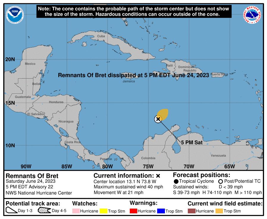
000
WTNT33 KNHC 242031
TCPAT3

BULLETIN
Remnants Of Bret Advisory Number  22
NWS National Hurricane Center Miami FL       AL032023
500 PM EDT Sat Jun 24 2023

...BRET OPENS INTO A TROUGH...
...THIS IS THE LAST NHC ADVISORY...


SUMMARY OF 500 PM EDT...2100 UTC...INFORMATION
----------------------------------------------
LOCATION...13.1N 73.8W
ABOUT 160 MI...260 KM WNW OF NTHRN TIP OF GUAJIRA PNSULA COLOMBIA
MAXIMUM SUSTAINED WINDS...40 MPH...65 KM/H
PRESENT MOVEMENT...W OR 270 DEGREES AT 21 MPH...33 KM/H
MINIMUM CENTRAL PRESSURE...1007 MB...29.74 INCHES


WATCHES AND WARNINGS
--------------------
There are no coastal watches or warnings in effect.


DISCUSSION AND OUTLOOK
----------------------
At 500 PM EDT (2100 UTC), the remnants of Bret were located near
latitude 13.1 North, longitude 73.8 West. The remnants are moving
toward the west near 21 mph (33 km/h).

Maximum sustained winds are near 40 mph (65 km/h) with higher gusts.

Tropical-storm-force winds extend outward up to 115 miles (185 km)
north of the center.

The estimated minimum central pressure is 1007 mb (29.74 inches).


HAZARDS AFFECTING LAND
----------------------
SURF:  Swells generated by the remnants of Bret will affect coastal
areas adjacent to the central Caribbean Sea through tonight.  These
swells could cause life-threatening surf and rip current conditions.
Please consult products from your local weather office.


NEXT ADVISORY
-------------
This is the last public advisory issued by the National Hurricane
Center on Bret. Additional information on this system can be found
in High Seas Forecasts issued by the National Weather Service,
under AWIPS header NFDHSFAT1, WMO header FZNT01 KWBC, and online at
ocean.weather.gov/shtml/NFDHSFAT1.php

$$
Forecaster Cangialosi
Public Advisory not available for this storm.
Remnants Of BRET Forecast Discussion
000
WTNT43 KNHC 242031
TCDAT3

Remnants Of Bret Discussion Number  22
NWS National Hurricane Center Miami FL       AL032023
500 PM EDT Sat Jun 24 2023

Satellite images, surface observations, and ASCAT data from a few
hours ago indicate that Bret no longer has a well-defined low-level
center.  The structure of the system more resembles an open wave or
trough with a couple of embedded vorticity maximums.  Therefore, the
system does not meet the criteria needed to be considered a tropical
cyclone, and this is last advisory issued by NHC.

The remnants of Bret are still producing 35-kt winds in areas of
showers and thunderstorms just north of the northeastern portion of
Colombia.  These winds are expected to decay as the system continues
to move quickly westward.

This is the last advisory on Bret.  However, additional and future
information on this system can be found in High Seas Forecasts
issued by the National Weather Service, under AWIPS header
NFDHSFAT1, WMO header FZNT01 KWBC, and online at
ocean.weather.gov/shtml/NFDHSFAT1.php


FORECAST POSITIONS AND MAX WINDS

INIT  24/2100Z 13.1N  73.8W   35 KT  40 MPH
 12H  25/0600Z...DISSIPATED

$$
Forecaster Cangialosi
BRET storm path from NHC
| Time | Speed | Location | Status |
|---|---|---|---|
| 35 knots | 13.1, -73.8 | ||
| 0 knots | translation missing: en.DISSIPATED |
site by Hayley Croft
- Tell your friends about Cyclocane
- make a donation - totally optional but completely appreciated
Make a monthly donation or a one-time donation to help support ongoing costs with Cyclocane.
Play solitaire and track all of the cyclocane storms at the same time at Hurricane Solitaire.