Cyclocane
( cyclocane is a CYCLOne and hurriCANE tracker by hayley )


English Español Deutsch Français 日本語
This is the final warning / advisory for this storm as it has weakened below warning levels and/or the storm system is no longer a tropical cyclone.
ARLENE Current Status
Current Wind Speed 25 knots / 30 MPH
Max Predicted Wind Speed 25 knots / 30 MPH at

Current Watches/Warnings / Radar / Satellite
current US watches/warnings

live tornado/thunderstorm tracker - tornadohq
future radar imagery - my future radar

future radar imagery

(above image is an example of the Western North Atlantic page - see Atlantic future radar page for a full set of images)
If a tropical storm or hurricane is threatening land, you can check my future radar for an idea of what radar might look like as the storm approaches.
ARLENE Land Hazards
NWS Local Hurricane Statements
- No warnings
- RAINFALL - Rainfall amounts of 1 to 2 inches with localized higher amounts up to 5 inches are possible into this evening across portions of the southern Florida Peninsula. The heavy rainfall could lead to isolated flash, urban, and small stream flooding impacts.
ARLENE Tracker
ARLENE Satellite Loop
ARLENE Alternate Tracking Map
ARLENE Spaghetti Models
Spaghetti models for ARLENE can be found here:
ARLENE spaghetti models page »
ARLENE Watches and Warnings
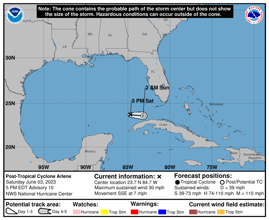
Post-Tropical Cyclone ARLENE Tropical Cyclone Update
Post-Tropical Cyclone ARLENE Public Advisory
000
WTNT32 KNHC 032038
TCPAT2

BULLETIN
Post-Tropical Cyclone Arlene Advisory Number  10
NWS National Hurricane Center Miami FL       AL022023
500 PM EDT Sat Jun 03 2023

...ARLENE NOW A REMNANT LOW...
...THIS IS THE LAST ADVISORY...


SUMMARY OF 500 PM EDT...2100 UTC...INFORMATION
----------------------------------------------
LOCATION...23.7N 84.7W
ABOUT 135 MI...215 KM WSW OF THE DRY TORTUGAS
MAXIMUM SUSTAINED WINDS...30 MPH...45 KM/H
PRESENT MOVEMENT...SSE OR 150 DEGREES AT 7 MPH...11 KM/H
MINIMUM CENTRAL PRESSURE...1001 MB...29.56 INCHES


WATCHES AND WARNINGS
--------------------
There are no coastal watches or warnings in effect.


DISCUSSION AND OUTLOOK
----------------------
At 500 PM EDT (2100 UTC), the center of Post-Tropical Cyclone Arlene
was located near latitude 23.7 North, longitude 84.7 West. The
post-tropical cyclone is moving toward the south-southeast near 7
mph (11 km/h). A turn to the east is expected by tonight, and that
motion should continue until the system dissipates.

Maximum sustained winds are near 30 mph (45 km/h) with higher gusts.
Continued weakening is forecast, and Arlene is expected to dissipate
on Sunday.

The estimated minimum central pressure is 1001 mb (29.56 inches).


HAZARDS AFFECTING LAND
----------------------
RAINFALL: Rainfall amounts of 1 to 2 inches with localized higher
amounts up to 5 inches are possible into this evening across
portions of the southern Florida Peninsula. The heavy rainfall
could lead to isolated flash, urban, and small stream flooding
impacts.


NEXT ADVISORY
-------------
This is the last public advisory issued by the National Hurricane
Center on Arlene.  For additional information on the remnant
low, see High Seas Forecasts issued by the National Weather Service
under AWIPS header NFDHSFAT1, WMO header FZNT01 KWBC, and online at
ocean.weather.gov/shtml/NFDHSFAT1.php

$$
Forecaster Cangialosi
Public Advisory not available for this storm.
Post-Tropical Cyclone ARLENE Forecast Discussion
000
WTNT42 KNHC 032039
TCDAT2

Post-Tropical Cyclone Arlene Discussion Number  10
NWS National Hurricane Center Miami FL       AL022023
500 PM EDT Sat Jun 03 2023

Arlene has lacked organized deep convection for quite some time now,
since about 07Z.  There have been a few short-lived small bursts of
convection in the northeast quadrant, but they have been getting
quickly sheared off and lack organization.  Therefore, Arlene no
longer meets the definition of a tropical cyclone and the system is
now a remnant low.  The initial intensity is estimated to be 25 kt
based on a partial ASCAT pass, surface observations, and the earlier
reconnaissance data.  Strong vertical wind shear and dry air should
continue to cause weakening, and this system is expected to open
into a trough on Sunday.

The low pressure area is moving south-southeastward at 6 kt.  A turn
to the east is expected tonight and that motion should continue
until the system dissipates.  The remnant low will likely enhance
rainfall over portions of southern Florida through tonight.

This is the last NHC advisory on Arlene.  For more information,
see High Seas Forecasts issued by the National Weather Service
under AWIPS header NFDHSFAT1, WMO header FZNT01 KWBC, and online at
ocean.weather.gov/shtml/NFDHSFAT1.php

FORECAST POSITIONS AND MAX WINDS

INIT  03/2100Z 23.7N  84.7W   25 KT  30 MPH...POST-TROPICAL
 12H  04/0600Z 23.6N  83.2W   20 KT  25 MPH...POST-TROP/REMNT LOW
 24H  04/1800Z...DISSIPATED

$$
Forecaster Cangialosi
ARLENE storm path from NHC
| Time | Speed | Location | Status |
|---|---|---|---|
| 25 knots | 23.7, -84.7 | translation missing: en.POST-TROPICAL | |
| 20 knots | 23.6, -83.2 | POST-TROPICAL CYCLONE | |
| 0 knots | translation missing: en.DISSIPATED |
site by Hayley Croft
- Tell your friends about Cyclocane
- make a donation - totally optional but completely appreciated
Make a monthly donation or a one-time donation to help support ongoing costs with Cyclocane.
Play solitaire and track all of the cyclocane storms at the same time at Hurricane Solitaire.