Cyclocane
(cyclocane is a CYCLOne and hurriCANE tracker)
English Español Deutsch Français
ERIKA Current Status
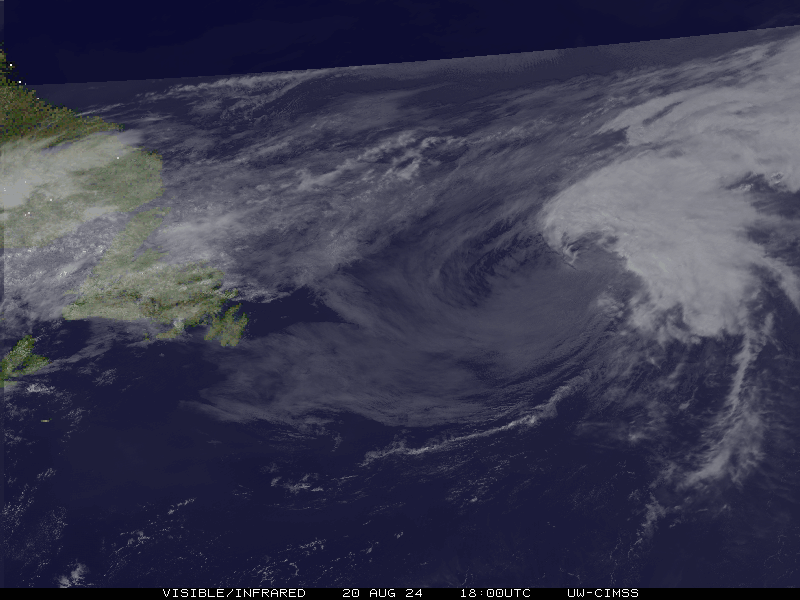
...ERIKA DEGENERATES TO A TROUGH OF LOW PRESSURE...
Current Wind Speed 30 knots / 35 MPH
Max Predicted Wind Speed 30 knots / 35 MPH at

ERIKA Land Hazards
NWS Local Hurricane Statements
- No warnings
ERIKA Tracker
ERIKA Satellite Loop
ERIKA Alternate Tracking Map
ERIKA Spaghetti Models
Spaghetti models for ERIKA can be found here:
ERIKA Watches and Warnings
- map legend
- red = Hurricane Warning
- purple = Hurricane Watch
- blue = Tropical Storm Warning
- green = Tropical Storm Watch
REMNANTS OF ERIKA Tropical Cyclone Update
REMNANTS OF ERIKA Public Advisory
ZCZC MIATCPAT5 ALL
TTAA00 KNHC DDHHMM

BULLETIN
REMNANTS OF ERIKA SPECIAL ADVISORY NUMBER  19
NWS NATIONAL HURRICANE CENTER MIAMI FL       AL052015
930 AM EDT SAT AUG 29 2015

...ERIKA DEGENERATES TO A TROUGH OF LOW PRESSURE...


SUMMARY OF 930 AM EDT...1330 UTC...INFORMATION
----------------------------------------------
LOCATION...21.5N 75.9W
ABOUT 130 MI...205 KM E OF CAMAGUEY CUBA
ABOUT 260 MI...420 KM SSE OF NASSAU
MAXIMUM SUSTAINED WINDS...35 MPH...55 KM/H
PRESENT MOVEMENT...WNW OR 290 DEGREES AT 22 MPH...35 KM/H
MINIMUM CENTRAL PRESSURE...1011 MB...29.86 INCHES


WATCHES AND WARNINGS
--------------------
CHANGES WITH THIS ADVISORY:

All coastal watches and warnings are discontinued.

SUMMARY OF WATCHES AND WARNINGS IN EFFECT:

There are no coastal watches or warnings in effect.

Interests in the Bahamas, eastern and central Cuba, and southern
Florida should monitor the progress of the remnants of Erika.


DISCUSSION AND 48-HOUR OUTLOOK
------------------------------
At 930 AM EDT (1330 UTC), the remnants of Erika were estimated near
latitude 21.5 North, longitude 75.9 West. The remnants are moving
toward the west-northwest near 22 mph (35 km/h).  This general
motion should continue for the next 24 hours or so, with the
remnants expected to move near the coast of eastern and central
Cuba today and tonight and into the southeastern Gulf of Mexico on
Sunday.

Maximum sustained winds are near 35 mph (55 km/h) with higher gusts.

The estimated minimum central pressure is 1011 mb (29.86 inches).


HAZARDS AFFECTING LAND
----------------------
RAINFALL: The remnants of Erika are expected to produce total
rainfall accumulations of 3 to 6 inches with maximum amounts of 10
inches possible across portions of the Dominican Republic, Haiti and
eastern and central Cuba through Sunday.  These rains could cause
life-threatening flash floods and mud slides. In addition, rainfall
amounts of 1 to 3 inches are expected across the Turks and Caicos
Islands as well as the southeastern and central Bahamas through
Sunday.  Rainfall amounts of 3 to 5 inches, with locally heavier
amounts, are possible across southern and central Florida beginning
on Sunday.

WIND: Gusts to tropical storm force are expected in squalls over
portions of the Turks and Caicos Islands and the southeastern
Bahamas for the next several hours.  These conditions are expected
to spread into the central Bahamas this afternoon and tonight.
Gusts to tropical storm force in squalls are also possible over
eastern Cuba today.  Gusty winds could occur over southern Florida
beginning on Sunday.


NEXT ADVISORY
-------------
This is the last public advisory issued by the National Hurricane
Center on this system.  Additional information on this system will
be available in Tropical Weather Outlooks issued by the National
Hurricane Center, as well as marine forecasts and local forecast
office products issued by the National Weather Service.

$$
Forecaster Beven

NNNN
Public Advisory not available for this storm.
REMNANTS OF ERIKA Forecast Discussion
000
WTNT45 KNHC 291331
TCDAT5

REMNANTS OF ERIKA SPECIAL DISCUSSION NUMBER  19
NWS NATIONAL HURRICANE CENTER MIAMI FL       AL052015
930 AM EDT SAT AUG 29 2015

Surface observations from Cuba, satellite imagery, and reports from
an Air Force Reserve Hurricane Hunter aircraft indicate that Erika
has degenerated into a trough of low pressure, with the remnants of
the center located near the north coast of eastern Cuba.  Winds of
near 30 kt are occurring to the north and east of the center, and
these conditions will likely continue through at least this
afternoon.

The remnants are expected to move west-northwestward near the
northern coast of central and eastern Cuba for the next 12 to 24
hours and reach the southeastern Gulf of Mexico in about 36 hours.
After that time, a more northward motion is expected over the
eastern Gulf of Mexico.

The dynamical models suggests that the current strong wind shear
could relax by the time the system reachs the Gulf of Mexico, and
there is a possibility that Erika could regenerate.  Regardless of
regeneration, locally heavy rains and gusty winds should spread
across portions of Cuba, the Bahamas, and southern Florida during
the next couple of days.

This will be the last advisory on this system by the National
Hurricane Center unless regeneration occurs.  Additional information
can be found in the Tropical Weather Outlook issued by the National
Hurricane Center, as well as marine forecasts and local forecast
office products issued by the National Weather Service.


FORECAST POSITIONS AND MAX WINDS

INIT  29/1330Z 21.5N  75.9W   30 KT  35 MPH...REMNANTS
 12H  29/1800Z...DISSIPATED

$$
Forecaster Beven
ERIKA storm path from NHC
| Time | Speed | Location | Status |
|---|---|---|---|
| 30 knots | 21.5, -75.9 | translation missing: en.REMNANTS | |
| 0 knots | , | translation missing: en.DISSIPATED |
Want to help support this site?
- Tell your friends about Cyclocane
- Help Hayley pay the web hosting bill by buying something through this
Play solitaire and track all of the cyclocane storms at the same time at Hurricane Solitaire.